

Essay · · 66 min read
What the City Was
Part 1 of three. Seven places where the Twin Cities were made, and what it cost the people who were already there.

"Where everything began and where everything began changing."
Dave Larsen, Dakota elder, on Bdote
Bdote
Stand at the eastern point of Pike Island and watch the two rivers arrive. The Minnesota comes in brown with prairie silt. The Mississippi comes in clearer. For a stretch they run side by side in one channel with a seam between them, and then the seam is gone. Every few minutes a plane drops toward the airport, low enough that you feel it in the chest before you hear it. Up on the bluff behind you, the fort looks down on all of it.
The Dakota name for this place is Bdote, where two waters come together. Many Dakota people hold it as the place of creation, where the first people were shaped from the clay of the earth. Sheldon Wolfchild, of the Lower Sioux community, put it in seven words: "This is where the Dakota people began."
That story is not mine to tell. I am a newcomer to this ground, and what I can do is read the paperwork. The state kept it, with dates, signatures and dollar amounts, and it kept other things too, which I will get to. The founders' city begins on this island, with a piece of paper.
On 23 September 1805, Lieutenant Zebulon Pike met Dakota leaders here and asked for land for military posts, including the confluence, St. Anthony Falls upriver, and the mouth of the St. Croix. Seven leaders were present. Two signed. No price was written in. Pike handed out about $200 in gifts, and liquor, and in his own reckoning valued the land at $200,000. In 1808 the Senate wrote in a price itself, $2,000, with no Dakota in the room. No president ever proclaimed the agreement, and in 1856 a Senate committee found no evidence the Dakota had ever been bound by it. The fort went up on the land anyway.
Do it in pennies. The man who wrote the paper valued the ground at $200,000, and the Senate would later write in $2,000, a penny on the dollar. The ground included the waterfall that in 1916 would grind more than a fifth of the nation's flour.
The soldiers came in 1819 and began the stone fort on the bluff the next year, under Colonel Josiah Snelling, whose name it still carries. It was built to hold the river for the fur trade and keep the British out. Officers, officials and fur traders brought enslaved people with them, and between fifteen and thirty at a time lived at the fort through the 1820s and 1830s. Harriet Robinson married Dred Scott there. The suit that carried his name to the Supreme Court rested in part on the years he spent on this ground, and the Court answered by ruling that no descendant of enslaved Africans could be a citizen, and that Congress could not bar slavery from the territories.
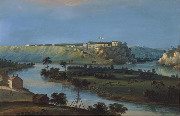
The large taking came in the summer of 1851, in two treaties signed thirteen days apart: at Traverse des Sioux on 23 July, and on 5 August at Pilot Knob, the bluff above Mendota with a view down onto this island. Together they handed the United States roughly 24 million acres across what are now Minnesota, South Dakota and Iowa, an area about the size of Indiana. By the Historical Society's figure the price at Traverse des Sioux came to about seven and a half cents an acre: less than a dime for a piece of prairie nearly the size of a football field. Most of that never arrived as money. The government kept more than four-fifths of the Traverse des Sioux sum and promised to pay the interest.
After the leaders signed the treaty copies, a third document was put in front of them. No one read it aloud or translated it, and many of them took it for another copy of the treaty. It sent about a third of the Dakota cash payments to the traders, Henry Sibley among them. At Mendota one of the two commissioners, Luke Lea, offered the alternative as a supposition: if the Great Father wanted their land and not a treaty for their good, "he could come with 100,000 men and drive you off to the Rocky Mountains." Then the Senate struck out the article that would have secured the Dakota a reservation along the Minnesota River, and ratified the rest, on the condition that the Dakota accept the change.
Eleven years later the money was late. In the summer of 1862 the annuity did not come, and when Dakota leaders asked the traders for credit to carry them until it did, the traders refused. One of them, Andrew Myrick, set out the reasoning in a letter to his brothers on 26 July: they had "determined not [to] give any more credit hoping to starve them into a change of sentiment." The famous line, that if the Dakota were hungry they could eat grass, may never have left his mouth, and the story that he was found dead with grass stuffed in it may be no truer. The letter is documented. By August the Dakota were starving. The war began on 17 August, when four Dakota hunters killed five settlers at Acton, and on the morning of the 18th the Lower Sioux Agency was attacked. Myrick was among the first killed.
The war lasted about six weeks. The Historical Society's counts of the white dead run from about four hundred to more than six hundred, settlers and soldiers together. How many Dakota died in the fighting nobody recorded. Many Dakota refused to fight, and some hid settlers from it. What came after made no such distinction. On 9 September, Governor Alexander Ramsey told a special session of the Legislature that the Dakota "must be exterminated or driven forever beyond the borders of Minnesota." The line was not in his prepared text.
A military commission tried 392 men, moving faster as the weeks went on, and sentenced 303 to death. The legal scholar Carol Chomsky describes defendants "unrepresented in unfamiliar proceedings conducted in a foreign language." Lincoln cut the list to 39 and reprieved one more. On 26 December 1862 thirty-eight men were hanged together on a single scaffold at Mankato, while about 4,000 people crammed the streets to watch. The Historical Society calls it the largest mass execution in the nation's history. At least two of the dead should not have been up there. One reportedly stepped forward when the name Caske, a common one, was called. Another, Wasicuƞ, a white man the Dakota had adopted as a boy, had been acquitted.
The bodies were hauled to a shallow mass grave on a sandbar between Mankato's main street and the river. Before morning, physicians had dug most of them up for cadavers. One of the doctors was William Mayo. By the historic accounts he took the body of Marpiya Okinajin, called Cut Nose, to his office, dissected it, and made a skeleton of it. A skull stayed on display until 1998, when the Mayo clinic returned two skulls to the Dakota. One was confirmed as Cut Nose's. The clinic says it does not know what became of the skeleton. It apologized in 2018.
The rest of the people came here. On 7 November about 1,700 Dakota, most of them women and children, were moved out of the Lower Sioux Agency in a column that took six days to reach this fort, about 150 miles. At Henderson a crowd met them with guns, knives, clubs and stones. Samuel Brown, who was there, saw people drag old men, old women and children out of the wagons by the hair. He saw a white woman "snatch a nursing babe from its mother's breast and dash it violently to the ground." The baby was handed back. It died later, and its people laid it in the crotch of a tree.
They were held through the winter in a camp on the river flats below this bluff. The historian Mary Wingerd calls it "essentially a concentration camp." Measles went through it, and other diseases with it. Gabriel Renville, Tiwakan, remembered that "it seemed doubtful at night whether a person would be alive in the morning." The Historical Society's counts of the dead run from 102 to 300 on one of its pages and from 130 to 300 on another, and nobody counted well enough to narrow it. These, Wingerd says, "are people who were guilty of nothing."
Early in 1863 Congress voided every treaty it had made with the Dakota. In April the men Lincoln had held back went downriver by steamboat to a military prison at Davenport, Iowa, where at least 120 of them died. In May about 1,300 people from the camp were loaded onto steamboats for Crow Creek in Dakota Territory, which Wingerd calls "the next best thing to hell." More than 200 died in the first six months there, most of them children.
By then a Dakota found in Minnesota could be killed for money. In July the state began paying bounties for Dakota scalps: $25 to its volunteer scouts, and $75 offered to civilians, raised in September to $200. Late on the afternoon of 3 July 1863, Little Crow, Taoyateduta, who had led the Dakota in the war, was picking berries in a thicket northwest of Hutchinson when Nathan Lamson and his son Chauncey shot him. On the Fourth of July settlers scalped the body and took it into town for the celebration, and while they argued over whether it was really him, they mutilated it further. The State of Minnesota sent Nathan Lamson a check for $500. The scalp was tanned and displayed in the adjutant general's office. In 1868 it was given to the Minnesota Historical Society, which already had his skull and some of his bones, and the Society exhibited all three until 1915. He was buried in 1971, in a family plot near Flandreau, South Dakota, more than a century after he was shot.
That is the institution whose counts I have been quoting. Its counts are good. It also kept a dead man's scalp, skull and bones on show until 1915. I am going to keep quoting it. A receipt can be accurate and still come from a dirty hand.
Put it in a single sentence and see whether a softer word will fit: a governor called for extermination before the fighting was over, the state then paid by the scalp, and people charged with nothing were marched past mobs, held through a winter of measles, stripped of every treaty and shipped to a place where their children died by the hundred. Governor Walz apologized in 2019, on the anniversary of the hanging, "for what happened to the Dakota people." Mayo apologized in 2018, acknowledging "our role in that broken relationship." As reported, neither apology used the word. I will. The United Nations convention defines genocide as acts committed with intent to destroy a national, ethnical, racial or religious group in whole or in part, including killing its members and deliberately inflicting conditions of life calculated to bring about its physical destruction. Read the sentence above against that and tell me which part doesn't fit. The convention dates from 1948, and I know of no court that has applied it to 1862. Gary Clayton Anderson, who knows this history far better than I do, calls the forced removal of Indians westward "ethnic cleansing." The one line I found from him on the other word is garbled in the paper that printed it, so I won't guess where he lands. I think the record answers the question.
The record has not changed. The signs have, and then changed back. In 2019 the Historical Society added two words to its signs here, so that they read Historic Fort Snelling at Bdote. The state Senate Finance Committee threatened to cut its state funding. The signs came down that same year, the Society citing "public confusion." In 2022 the fort reopened after a $34.5 million rebuild, with new exhibits on the 1805 agreement, on slavery and on Japanese Americans alongside the military story, and the same year the Society's board voted unanimously to keep the old name. Up the river road, the spring the Dakota call Mni Ówe Sni still runs through its old reservoir and down to the river, listed by the federal government since 2023 as a Traditional Cultural Place.
Go back to the point of the island and watch the water again. The seam holds for a while and then there is no seam, and a stranger would swear it was always one river. Nobody standing there now can see the join.
I can see it. I have the dates, the dollar figures, and a dead man's scalp in a state museum case until 1915. So here is what the place is. It's a crime scene with a hiking trail. The colonel's name is still on the bluff. The man who said exterminate has a county named after him, and Saint Paul sits in it. Sibley, whose claims were paid out of that third document nobody read aloud, got a county and a governorship.
I don't know how to fix that, and I'd distrust any writer who said they did. What I have is the paperwork, and a refusal to start the story somewhere cleaner.
Pike's paper covered the falls too.
The Falls
Stand on the Stone Arch Bridge and face upstream. The river slides down a long concrete ramp, white at the lip, churning at the foot. It looks like a waterfall the way a stage set looks like a house. Now look at the water below it. Just downstream of the falls there was an island.
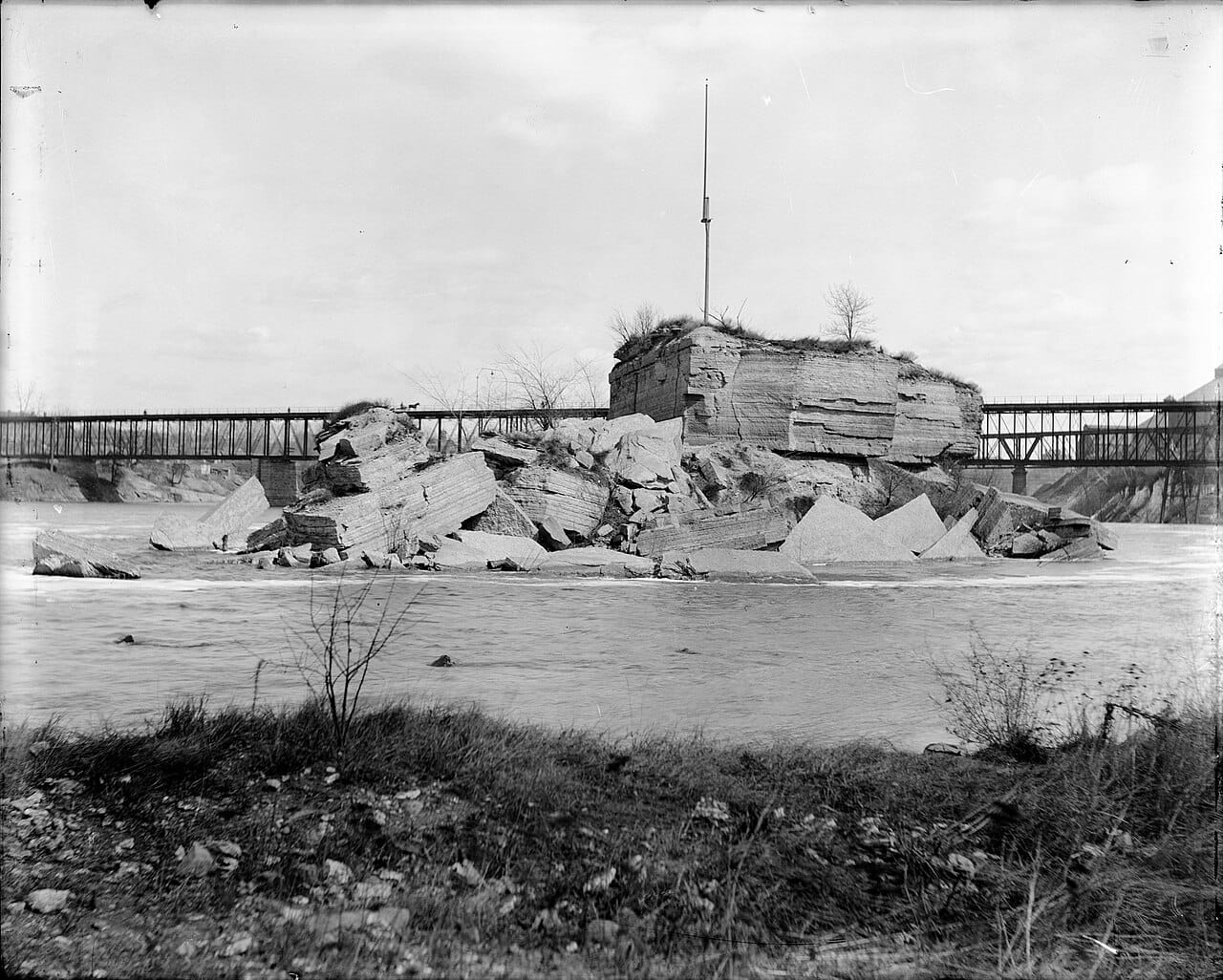
The Dakota call the falls Owámniyomni. Early visitors wrote down other Dakota names: the curling water, the whirlpool, the big waterfall. Ojibwe names on record include Kakabikah, the severed rock, which the Park Service ties to the broken limestone below the falls and the Army Corps ties to the falls themselves. Just below them sat Wíta Wanáǧi, Spirit Island, about an acre of limestone. Jonathan Carver saw it in 1766 with several trees on it and "a vast many eagles' nests." Women are said to have come to the falls to give birth in the mist. Shelley Buck, of Prairie Island, who now leads the Dakota organization restoring this ground, says the place "connected the spirit world and the living world." In 1820 Henry Schoolcraft watched Dakota people dig a brownish red clay from under the falls and wrote that they "pretend that it is renewed when taken away." The National Park Service, in its own history of the river, answers him across nearly two centuries: "The Dakota, of course, were not pretending."
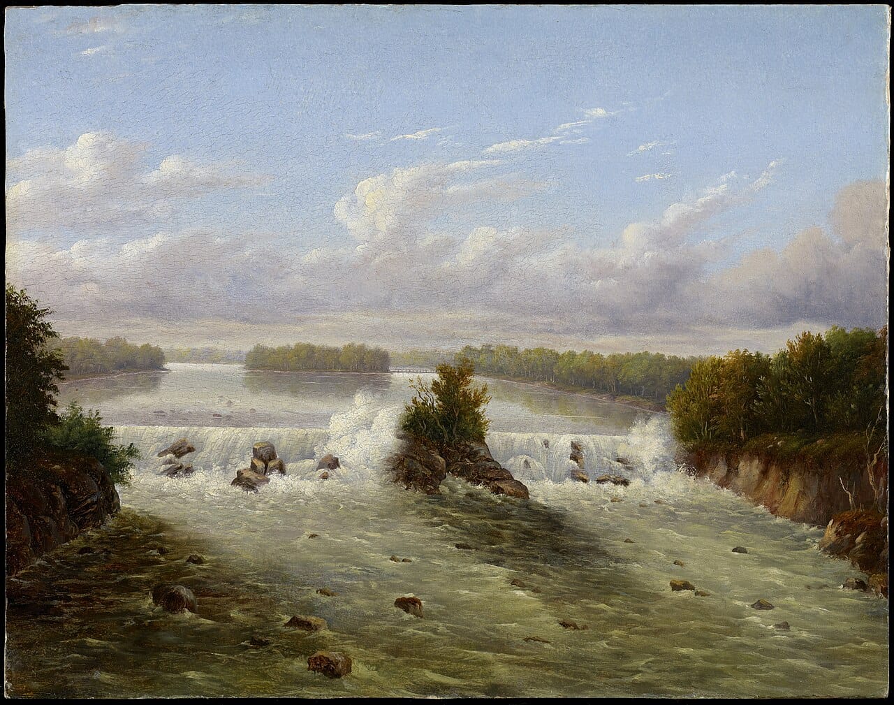
The city ate the island. It was quarried for building stone, and by 1899, in one historian's estimate, a sixth of it was left. In 1960 the Army Corps of Engineers began hauling away the rest to make room for the lock. By 1963 there was no Spirit Island. The falls got the same treatment, trimmed to fit. They once ran something like 1,250 or 1,500 feet across, depending on who measured. About 350 feet is left, roughly a quarter.
Pike's paper from 1805 covered the falls, and for decades the army sat on them. Soldiers under Colonel Snelling built a sawmill and a gristmill on the west bank between 1821 and 1823 to keep the fort fed. By 1837 there were 157 squatters on the military reservation, waiting. That year the commandant, Joseph Plympton, surveyed the reservation's boundary and drew it so the east shore of the falls fell outside, though Pike's cession plainly took it in. He wanted it for himself. News that the treaty opening the east bank had been ratified came up on the steamboat Palmyra on 15 July 1838. Franklin Steele, the fort's sutler, about twenty-five years old, had his claim staked in the middle of the night, and Plympton's men lost.
Steele needed timber for a dam and a mill. He bought it from the Ojibwe leader Hole-in-the-Day at fifty cents a tree. By March 1848 his crews had cut about a million and a half board feet. Eastern money paid him $12,000 for nine-tenths of the claim, and that September he got title. The Minnesota Historical Society's own encyclopedia, revised in 2025, calls him a "war profiteer" who "exploited the legal system to swindle tens of thousands of acres set aside by treaties specifically for Indigenous people." He was Henry Sibley's brother-in-law. When the army gave up Fort Snelling itself, Steele bought it for $90,000 on a tip from Henry Rice, then the territory's delegate in Congress. The money Steele raised for the purchase included $30,000 in checks he sent Rice personally.
The west bank opened more slowly and for the same kind of men. In 1852 Congress cut more than 26,000 acres out of the fort's reserve. By 1854 about 300 squatters had settled on it, and in 1855 Congress gave them the right to buy what they were sitting on. A year later the water power on each bank went to a private company with a perpetual charter, the Minneapolis Mill Company on the west and the St. Anthony Falls Water Power Company on the east. By 1865 the Washburn brothers, Dorilus Morrison and Robert Smith owned the west-side company outright. A waterfall had turned into a company, and the company sold the drop.
First it sold pine. Sawmill output at the falls went from about 12 million board feet in 1856 to about 90 million in 1869, when eighteen lumber mills ran there. The Park Service says the timber milling "spurred the clear-cutting of Minnesota's forests." The logs came down from the north, out of Ojibwe country. How that country was taken is its own story, and I have not read enough of it to tell it here.
Then the falls nearly went. In 1865 William Eastman and John Merriam bought much of Nicollet Island and sued the east-side company for water. The settlement let them dig a tailrace tunnel under Hennepin Island, under the limestone ledge that held the whole falls in place. Digging began in September 1868. By 4 October 1869 the tunnel ran about 2,000 feet, and that day the river found it. The six-foot bore scoured out into a cavern as much as ninety feet wide, and the next morning the riverbed above it fell in. A witness described the city running to the edge: "bakers deserted their ovens, lumbermen were ordered from the mills, barbers left their customers unshorn." A local paper said the whirlpool tossed huge logs "as though they were mere whitlings." George Brackett directed the cofferdams, with the fire department, and hundreds of volunteers worked day and night for weeks. In April 1873 a flood broke one of them and drowned a man the sources I read do not name.
The nation paid to fix it. In 1870 Congress gave the Army Corps of Engineers $50,000. The Corps had no authority to work on the falls unless the job served navigation, so an engineer argued that navigation above Minneapolis would be lost, and Congress, reluctantly, accepted it. The mills were saved along with the boats. The Corps built a concrete cutoff wall, which it calls a dike, under the river between 1874 and 1876, 1,850 feet long, about a third of a mile, and in places about forty feet deep, a three- or four-story building laid on its side under the water. An apron, two low dams and a log sluice followed, finished by 1880. By the Corps' own count the federal government spent about $615,000 between 1870 and 1885. The Minneapolis Tribune promised that "this artificial fortress" would "stand guard for ages and defy the floods." Read the bill. Two private companies held a perpetual right to the river's power. Two investors dug a hole under it. The country filled the hole. The wall is still down there. A state-funded study this year found no evidence of impending failure. It did not settle who owns the wall, and it was never meant to.
With the river held in concrete, flour took over. Minnesota's hard spring wheat ground badly. Millers in southern Minnesota worked out a slower grinding in the 1860s. In the 1870s the Minneapolis mills adopted it and perfected it with porcelain and steel rollers, and the flour came out white. By 1880 Minneapolis was the top milling city in the country. In 1916 the mills at the falls turned out 18.5 million barrels, more than a fifth of all the flour milled in the country, about 50,000 barrels a day. Three companies, Washburn-Crosby, Pillsbury and Northwestern Consolidated, held nine-tenths of the capacity. Twenty-five mills ran on two to two and a half thousand people.
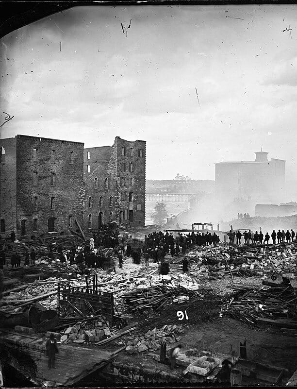
The flour could kill them. C. C. Washburn's A Mill, opened in 1874, was the largest mill in the world. On 2 May 1878 the night crew of fourteen came on at six. About an hour later the building blew, and the blast was heard in Saint Paul, ten miles away. Fire carried to the Diamond and Humboldt mills, which blew too. Eighteen people died. All fourteen of the night crew were among them, an hour into their shift. University of Minnesota professors worked out the cause: two millstones had run dry and struck a spark, and the spark found the flour dust that hung in the air. The Tribune wrote that the "suddenness and horror" of it were hard for the mind to take in. Washburn announced the next day that he would rebuild. The new A Mill opened in 1880, with ventilation for the dust. The eighteen names are cut into a monument at Lakewood Cemetery, put up in 1885.
In September 1903 more than a thousand flour workers met to demand an eight-hour day. The packers and nailers wanted the women who packed flour paid what the men were paid, so the companies could not use them to undercut the men's wages. They struck on 24 September, and the strike halted production in fourteen mills. By 9 October a majority of the mills had reopened with strikebreakers, recruiting students, the unemployed and people of color with a free train ticket, room and board and the promise of a permanent job. The strike collapsed before the month was out. A University of Minnesota labor timeline counts 1,800 strikers and calls the employers' win "a huge boost" for the Citizens Alliance, an anti-union association whose back the 1934 strikers would break thirty-one years later.
The money followed the wheat. Buffalo passed Minneapolis in 1930. The A Mill closed in 1965 and burned in 1991. The ruin you can walk through now, with sky where the floors were, was left by the 1991 fire, not the explosion of 1878. Since 2003 it has been the Mill City Museum. The upper lock closed to boats on the night of 9 June 2015, to keep invasive carp out of the river above it, though the Corps still runs it for flood control. In 2020 the Corps' land at the falls was ordered handed over to the city or its designee.
The city named its designee in April 2025: Owámniyomni Okhódayapi, the old Friends of the Falls, under Dakota leadership since 2023, with Shelley Buck as president. The plan covers 5.2 acres, with an endowment meant so that Dakota nations "will not inherit a financial burden for land taken from them." Construction began that June. The transfer of title, scheduled for this year, has slipped to early 2027, Buck says, because of bureaucratic hurdles. Up the bank, the Water Works pavilion stands on old mill foundations. ENTER magazine called its tenant Owamni, in 2022, Minnesota's first full-service Native American restaurant. Owamni left the pavilion in 2026 for the Guthrie Theater, where it reopened as Indígena by Owamni, and a French bistro called Arch and River is slated for the space. I could not find an opening date.
That is the nearest thing to a return anywhere in this essay, and it is small. Five acres, still waiting on a signature, beside a wall whose owner nobody has settled, at the bottom of a city that kept the rest. The men who took this place did it with a surveyor's line and a stake driven at midnight. The people giving a little of it back are doing it with forms, in an office, in 2027 if the forms clear. Dull as hell.
The Landing
Walk down to the foot of Jackson Street and stand at the edge of the water. Warner Road is at your back and the river is in front of you, and not much on the ground says a landing was ever here. Most of it came out in the 1950s to make room for the road. The Dakota name for the pale sandstone bluffs along this stretch is I-mni-za ska dan, little white rocks. It sits below the falls, and it is where the boats tied up.
One of the first men to sell whiskey here was Pierre Parrant, called Pig's Eye, a former voyageur and a bootlegger. The army kept clearing squatters off the Fort Snelling reservation, and he set up near Fountain Cave about 1838, then drifted downriver. The picture of him as a squinting, piggish drunk comes mostly from nineteenth-century writers, above all the historian J. Fletcher Williams, who embellished the legend, so treat it as a rumor with a pen. In 1841 a Catholic priest, Father Galtier, put up a log chapel to Saint Paul, and over the next few years the place took the saint's name instead of the bootlegger's. A bootlegger, a priest and a log chapel, and the priest won.
Then the boats came. In 1844 the landing saw 41 steamboat arrivals. In 1849 it saw 95. In 1857 George Merrick counted 965 arrivals by 99 boats, a figure a Park Service note cites, though the Park Service's own text says over a thousand. For 1858 the same note gives Merrick's 1,090 arrivals by sixty-two boats, and another Park Service page says 1,068. Either way it averages about three arrivals a day over the whole year, and the river was frozen for months of it, so the open season ran busier than that. Saint Paul had 1,112 people in 1850. Ten years later it had 10,401, more than nine times as many. The Minnesota Historical Society calls it one of the busiest steamboat landings in the country, until the railroads took the trade away in the late 1880s. In 1937 the WPA rebuilt it and named it Lambert's Landing.
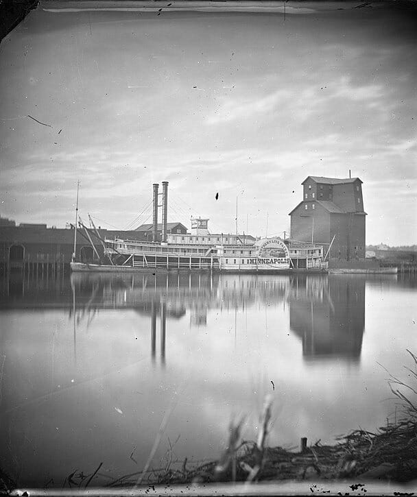
What came up the river was a country that wanted land. Some of it also wanted someone to carry its bags. In the summers of the 1850s, Southern families took rooms at hotels in St. Anthony, and some brought the people they owned. In 1860 a Mississippian named Richard Christmas brought Eliza Winston, who was forty-two, to look after his daughter and his sick wife. She had a husband, a free man, who had been saving to buy her freedom and died on a trip to Liberia. The state constitution adopted in 1857 outlawed slavery. The Supreme Court had said otherwise in Dred Scott that same year: living in a free state did not free an enslaved person. Her lawyer read a single sentence of the Minnesota constitution to a judge in Hennepin County, and on 21 August 1860 the judge, Charles Vanderburgh, an abolitionist, declared her free. Businessmen who feared for the tourist trade gathered outside the courthouse to protest. That night a gang surrounded the house of the abolitionist who had sheltered her, and by then she had disappeared to a safe house. The Historical Society says she faced white mob violence and was forced to leave the area. Southern tourism slowed for a few months. Then the South began leaving the Union.
Now the other direction. On 4 May 1863 the steamboat Davenport pulled away from this landing with about 770 Dakota people aboard, or 762 by the count of the Saint Paul papers. They were from the camp at Fort Snelling. A crowd was waiting on the levee. The St. Paul Press reported that a soldier wounded at Birch Coulee led it, and that it began throwing boulders at the people on the boiler deck, who were packed closely together. Several women were hit on the head and badly hurt. The next day the Northerner took 540 more, by the missionary John Williamson's count in a letter to his mother, though the St. Paul Press of 6 May gave 334. Together that is about 1,300 people, the number the Historical Society gives for that May. The Northerner had towed a raft of formerly enslaved people up from Missouri, led by Robert Hickman. The Park Service records that a mob "largely composed of Irish laborers" attacked them at this same Lowertown levee, and that the captain took them to Fort Snelling instead. The St. Paul Press, writing of the scenes at the levee, said no impartial spectator could fail "to assign the negro to a higher type of civilization than the white barbarians who howled around them as if, like beasts of prey, they thirsted for their blood."
The paper that made the city the capital was, for a while, the most argued-over piece of paper in the territory. In February 1857 the territorial legislature voted to move the capital out of Saint Paul to St. Peter, up the Minnesota River. The St. Peter Land Company wanted it enough to go to court. The story the city tells about what happened next belongs to Joe Rolette, a legislator and fur trader who is supposed to have vanished into a hotel room with the enrolled bill, drunk, playing cards, while the clock ran out. He did disappear with the bill, on 27 or 28 February, and he did not surface until 7 March. But the Historical Society says plainly that the claim he saved the capital "is untrue." The governor signed a copy anyway. That summer the St. Peter Land Company went to court to force the move through, and the territorial judge Rensselaer Nelson ruled that no valid law had been passed. The city's favorite story about itself is a story about a drunk. The real one is a court and a land company.
Then there is 1890, which is funny. The two cities ran about even through the 1870s. By 1880 Minneapolis had pulled ahead, with 46,887 people, a slim lead of about 5,000 by El-Hai's count. A census count mattered for seats in the legislature and for civic bragging rights. Both cities inflated theirs. Minneapolis set up a "Bureau of Information" under a man named Edward Stevens. Saint Paul picked the editor of its city directory, Theophilus Smith, to run its count. A private detective, John Mason, worked his way inside the Minneapolis bureau and swore later that Stevens handed him a list of typical ethnic names and told him to invent families. By the account in American Heritage, Mason made up 32 clans totaling 122 people. Of another man, Gus Plummer, he said Plummer "was not copying it from any list or paper, but filling it in from his own imagination."
On 17 June a deputy U.S. marshal arrested seven Minneapolis enumerators in the Vanderburgh Building and carried off six sacks of returns. Next morning, at the government building in Saint Paul, according to the Minneapolis lawyer William Henry Eustis, six policemen drew revolvers on the Minneapolis men who had come. One threw Captain Jake Hein out of the room, and an officer, Eustis said, "grabbed me and kicked me for at least sixteen feet." A Saint Paul paper said no one was kicked. Census superintendent Robert Porter went through both counts. Minneapolis had reported 182,967 people and Saint Paul 142,581. In Minneapolis he found a widespread conspiracy. In Saint Paul he found no conspiracy, only fraud and incompetence on a small scale: 275 people "permanently residing in the Union depot," 78 in a newspaper plant, 78 in a house still under construction, 25 in a hotel barbershop, and 34 in a one-story dwelling twelve feet by twenty. That last is 240 square feet, about seven apiece, about a bath mat each. The recount struck 18,229 names from Minneapolis and 9,425 from Saint Paul. A federal grand jury indicted 33 enumerators from both cities. Stevens and one other Minneapolis enumerator pleaded guilty, and a group of businessmen paid their fines. The Pioneer Press called its rival "this Jezebel, whose dallying with sin is the jest or the scorn," and Minneapolis took its subscriptions and advertising away, fifteen thousand dollars' worth, though El-Hai ties that to the arrests and the boycott more than to the insult.
Hold the two numbers side by side. In May 1863 the sources could not agree whether 770 Dakota people or 762 had boarded the Davenport, and nobody on the levee cared which. Twenty-seven years later a Saint Paul count had 275 people living in a train station, because a head was worth something on a ledger. The people on the boat got a rough count and a crowd. The people in the depot got a line in the book.
A neighborhood went too, and not to the flood. Across the water from downtown, on the low ground the city called the West Side Flats, a poor immigrant neighborhood grew from the 1850s on, frequently flooded, home to Irish, Jewish and Mexican workers and to Syrian families. The West Side Community Organization adds Lebanese and Black families. Our Lady of Guadalupe church opened there in 1931. In 1952 the worst flood in Saint Paul's recorded history heavily damaged the Flats. In 1956 the Port Authority announced the Riverview Industrial Park, a project that needed every acre of the Flats. The buyouts began in 1961, with 480 buildings to be razed and 2,147 people to be moved, by the Historical Society's count. The City Council and the Chamber of Commerce pushed for an approximately $4 million floodwall to protect the industrial park. By the end of 1963 the last residents had left, though MPR has the last families gone by 1962. George Avaloz, who grew up there, said they "made my family move because they were going to build the industrial center down there, and then they put the flood control in."
In 2024 Mayor Melvin Carter proposed expanding the city's Inheritance Fund, which began for Rondo families, to give down payment assistance to descendants of people displaced from property in the Flats. I could not find what became of it.
The flood did not take the Flats. The city did, and an industrial park stands there now behind a floodwall. I don't know what Saint Paul owes the people who were put on those boats at its landing.
The Car Line
Stand at Lake and Hennepin and wait for something to cross. I live in Uptown, so I have done this more often than I can count, and what crosses is a car, a bus, or a person, in about that order. For decades this corner was where two lines crossed. The Como-Harriet line came down Hennepin from Lagoon Avenue and met the Selby-Lake line right here. In 1898 a dime bought the whole seventeen miles of the Como-Harriet line, Lake Harriet to Como Park, and by 1906 the Selby-Lake line took you east over the Lake Street bridge into Saint Paul. Getting anywhere meant getting to a rail.
Thomas Lowry knew that, because he had arranged for it. Lowry became president of the Minneapolis street railway in 1878 and held the job until he died in 1909. The Historical Society says he cared about streetcars because he owned land outside the city and wanted it developed, and that more than a third of the property that is now Minneapolis passed through his hands. The Minneapolis horsecars began on 2 September 1875. The first electric line ran down Fourth Avenue South on 24 December 1889, and Saint Paul's followed on Grand Avenue two months later. By 1892 every horsecar line had been converted to electric. The company became Twin City Rapid Transit, and at its peak, in 1920, it carried more than 238 million riders a year. In the 1920s it ran more than 900 cars over some 520 miles of track. Spread over a year, those 238 million rides come to about 650,000 a day. In 2019 the whole Metro Transit system carried about 77 million, a third of that.
The line made the land. Two transportation researchers who studied the Twin Cities between 1900 and 1930 found that the houses thinned out past walking distance from a line, and that an area that gained a line within about half a mile got denser. The rails largely came first. The houses followed them. By 1930 Minneapolis had 3,500 multi-family dwellings, including many apartment buildings, and most were built near streetcar lines. Lake Street, Hennepin, University, Selby, Snelling grew their shops along the cars. The Lake Street Station opened in 1910, and it housed 180 cars and 500 employees.
In the fall of 1917 the company's president, Horace Lowry, fired fifty-seven men he took for union agitators. The rest walked out at one in the morning on 6 October. Saint Paul rioted. Minneapolis put six hundred armed deputies in the street. The state's Commission of Public Safety ordered the strikers back, and eventually forty-nine of the fired men returned. Lowry then set up a company union, with its own buttons, and the commission banned buttons on both sides. In December the Home Guard moved into Saint Paul, and the union's last push, a general strike on 13 December, collapsed in under four hours.
The line was also sold white. On 26 May 1910 Henry and Leonora Scott sold a property to a man named Nels Anderson, with a clause that barred any later sale to "any person or persons of Chinese, Japanese, Moorish, Turkish, Negro, Mongolian or African blood or descent." The Historical Society dates the arrival of covenants in Minneapolis to that sale. Scott became the first president of the Seven Oaks Corporation, a development company that put the same language into thousands of deeds across Minneapolis and Saint Paul. In the 1920s the hills between 46th Street and Minnehaha Creek were platted into 327 lots at Shenandoah Terrace, on a Chicago Avenue line the streetcar company had extended past the creek. A covenant was attached to each parcel. By Mapping Prejudice's account, the landowner who imposed it was a Catholic boys' orphan asylum.
Count them, and be careful what you count. Mapping Prejudice, at the University of Minnesota, has found 24,119 lots in Hennepin County carrying racial covenants, dated between 1910 and 1955. Those lots come from about 13,000 recorded deeds, because one deed could cover a whole subdivision. The worst single year was 1946, with 2,113 lots, from 419 deeds. Each lot was a house some family could not buy. Another 557 lots are dated 1949 or later, after the Supreme Court held in 1948 that no court could enforce them. Thirteen are dated 1954 or 1955, after Minnesota's 1953 ban on new ones. Two-thirds of the lots lie outside Minneapolis, in Richfield, Edina, St. Louis Park and the other suburbs.
The federal government meanwhile drew its own map. Between 1935 and 1940 the Home Owners' Loan Corporation graded neighborhoods by "residential security" and colored the riskiest red. Across the country, where the residents were Black, its appraisers called them a threat to home values and their presence "infiltration." I could not open the Minneapolis map itself, so I will not tell you how many of the city's Black residents lived inside the red.
The streetcar did not write a single covenant. The covenants followed the line out.
Then the line was cut. The war had filled the cars. Ridership went from 105 million in 1940 to almost 194 million in 1945, with 381 women hired as motorettes to drive them. By 1949 the company had 141 new PCC cars, the first delivered in 1945. After the war the cars emptied. A state highway report from 1963 compared the same part of the metro in 1949 and 1958. Total trips rose from about 1.6 million a day to nearly 2.5 million. Bus and streetcar trips fell, from 431,700 to 313,900, and their share dropped from 26.4 percent to 12.7, from about one trip in four to about one in eight. The 1958 count includes school buses, so the fall in transit riders is steeper than it looks. In the same area the share of shopping trips by bus went from 28 percent to 9, from more than a quarter to under a tenth. Nobody had to kill the streetcar. People were already leaving it. But in the 1958 study area, 69,000 of 408,000 dwelling units, about 17 percent, still had no car.
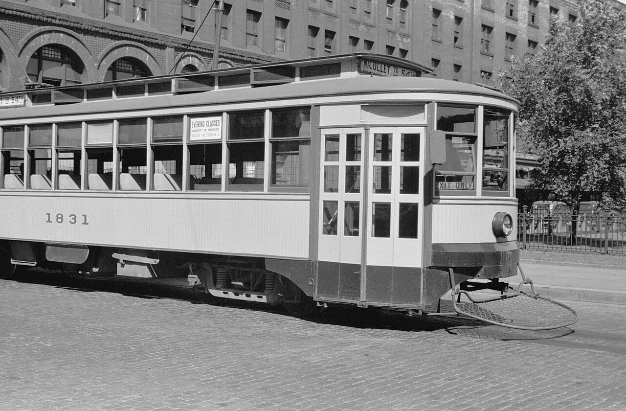
In November 1949 a New York investor named Charles Green, a substantial shareholder, was elected president of the company. By one transportation scholar's account he asked for a fare hike, fired a quarter of the workforce and cancelled capital spending. Fred Ossanna, the company's general counsel, ran a proxy fight against him and won. Ossanna became president in September 1951. The court calls Isadore Blumenfield, usually spelled Blumenfeld, a friend and close business associate of Ossanna's and the real owner of a substantial number of the company's shares. Minneapolis knew him as Kid Cann. The Eighth Circuit would later write that "the Ossanna administration embarked upon a program of rapid conversion from streetcars to busses." In a 2013 account the historian Kirsten Delegard describes the company celebrating the purchase of 525 buses, which she says were financed on liberal terms from General Motors. Saint Paul's last streetcars ran just after midnight on 31 October 1953. Minneapolis's last regular service ended in June 1954. The Historical Society holds a 1954 photograph of Ossanna, the company's chairman, smashing the window of a streetcar. On that early summer day the company burned streetcars, in Delegard's words, to demonstrate its commitment to progress and innovation.
You will hear that General Motors killed the streetcar. John Diers and Aaron Isaacs, who wrote the book on this system, call that an urban legend, and the Star Tribune reports that consumers simply preferred cars. The narrow true piece is this. Benson Larrick, later convicted with Ossanna, had worked twenty years for National City Lines, by the account of the Electric Railway Historical Association. That group says GM created National City Lines and was not involved in this conversion. It is an advocacy source, and its account sits badly beside Delegard's financing line. I could not reconcile them. The court's opinion mentions neither.
What Ossanna did was smaller and more specific. In 1959 a grand jury indicted Ossanna and five others on seventeen counts, thirteen of which reached a jury. On 6 August 1960 the jury convicted him of mail fraud, wire fraud, interstate transport of fraudulently obtained property and conspiracy. The appeals court, describing the case against the defendants, uses the indictment's phrase for the scheme: "to loot the Transit Companies." What got looted was what the conversion left behind. Cable the company's own crews pulled up, which the court valued near $938,000, went to a scrap company under a contract addendum on false weight tickets, and the company received $123,000. That is thirteen cents on the dollar. It sold 91 streetcars made surplus by the conversion to Mexico City for 20 percent down and ten notes. The board then authorized a sale of those notes to a man named George Francis at 40 percent off. The court found no evidence Francis ever made an offer. The notes were sold elsewhere, to banks at 87 to 92 percent of face, and Francis was paid $238,349.73 in commissions. The company abandoned a 3.6-mile line called the Hopkins right-of-way in 1951 and sold it in May 1955 for $10,000 to a man named Carlson, Ossanna's client, when it had been appraised at $84,500. That is about twelve cents on the dollar. Carlson resold the remainder for $126,075.56. Ossanna got four years, to run concurrently with a second four. Blumenfield was acquitted. The Eighth Circuit affirmed in March 1962.
In 1970 the public Metropolitan Transit Commission bought the system, for $7.9 million by one transportation scholar's uncited figure. The public bought what was left.
Walk back to Lake and Hennepin. The rails are under the asphalt somewhere, and the map of who got to live where is under the rails. The courts stopped enforcing the covenants in 1948, the state banned new ones in 1953, and the car line was struck from the street in 1954. The man who owned the land beside the rail was often the man selling the lots, and the lots came with the deed.
The Tower
Stand on the sidewalk under the Foshay Tower and tip your head back until your neck complains. Thirty-two stories, about 447 feet, and it narrows as it climbs. Each floor is about four inches smaller than the one below. The eye goes up and in. The man who built it said the idea came to him as a boy, when his father took him to see the Washington Monument. It is modeled on that, with offices. In 1929 it was the tallest thing in Minneapolis, and it held the title for forty-three years.
Minneapolis had claimed the idea of the skyscraper decades before, and it claimed it in court.
On 22 May 1888 the Patent Office gave a Minneapolis architect named Leroy Buffington Patent No. 383,170, "Iron Building Construction." Fire-proof buildings "composed chiefly of iron," with posts of "any desired height." He called the result a cloudscraper and drew one, twenty-eight stories and 350 feet. The trade press could not decide what he was, and I have its verdicts only secondhand, through an architecture historian's course notes. The Building Record of New York allowed that he was "neither a crank nor an ignoramus." The Architectural News said iron "is good in its place, but not to build buildings entirely of." He sued builders for using his idea. He spent about $30,000 on the suits and won none of them. The one royalty he ever saw was $2,250, paid voluntarily by the developer of the Rand Tower. That is about one dollar back for every thirteen he spent. No building went up on his system. Chicago's Home Insurance Building of 1885 usually gets the credit for the first skyscraper, and the Historical Society says the fight over who was first "died down without a clear resolution." Minneapolis had the patent for the idea two years before it had its tallest building.
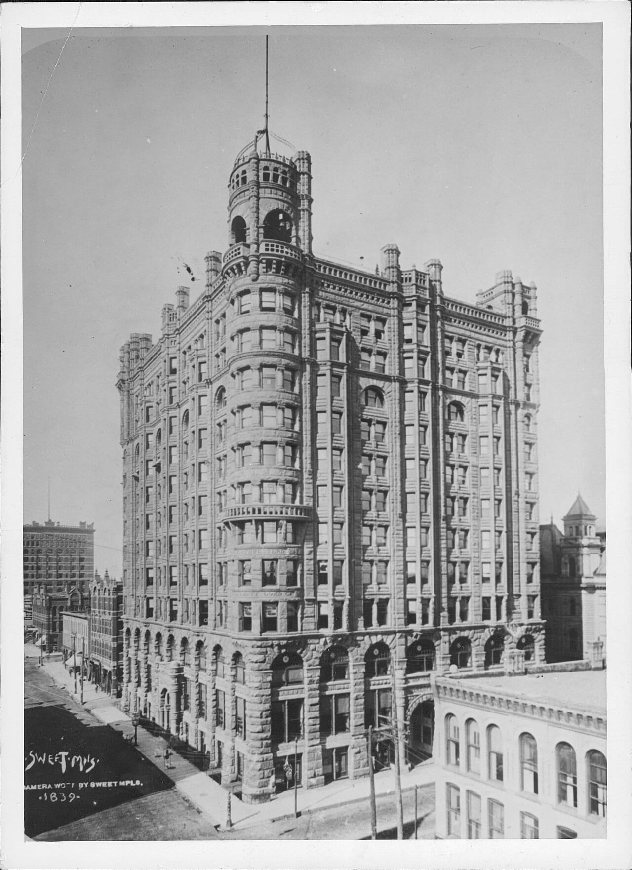
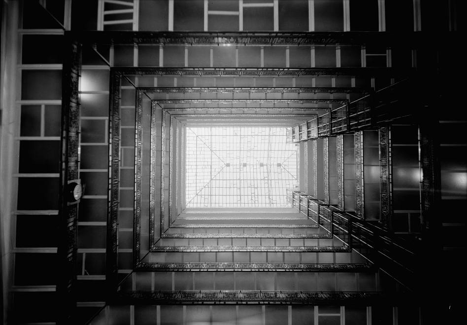
It got that building in 1890. The Northwestern Guaranty Loan Building, designed by E. Townsend Mix for a lender named Louis Menage, opened on 31 May 1890. The Hennepin History Museum counts 8,000 guests at the grand opening, and the historian Millett says thousands. Metropolitan Life bought it in 1905 and the name followed. It ran twelve stories. The University of Minnesota Press calls it the tallest, largest and most splendid commercial structure in Minneapolis. Through the middle ran a light court of iron and glass under a skylight, and the balconies around it had floors of thick translucent glass, so the daylight fell through every level to the halls below.
In 1917 the city tried to say what it wanted. A civic committee spent almost a decade, by MinnPost's count, on a Plan of Minneapolis, drawn by the architect Edward Bennett, with most of the words written by a Philadelphian named Andrew Wright Crawford. It had a large central civic square and a web of wide diagonal boulevards on the Parisian model, all to make the city "physically fit, structurally ready, for a population of 500,000." The plan argued that the wide streets would keep Minneapolis from being "infested by skyscrapers." A thousand copies were printed in September 1917. At least four of the original eleven committee members were dead by then, and the country was at war. MinnPost says almost none of the recommendations were ever adopted.
Then came Wilbur Foshay, who made his money in utility holding companies and wanted John Philip Sousa's band at the opening. The dedication ran three days, 30 August to 1 September 1929, over Labor Day weekend. The federal court that later tried him puts the crowd at 25,000, though Twin Cities Business says that was the invitation list. The dedication alone cost about $127,000, by the Historical Society's figure, against $3.75 million for the tower. That is about a dollar in thirty on a three-day party. Sousa supplied a march, "Foshay Tower Washington Memorial," recycled from one he had just finished for a women's college in Denton, Texas, and retitled. Foshay's check to Sousa bounced. Two months later the market crashed, and on 1 November his companies went into receivership. Sousa quietly withdrew the march, the Marine Band says, so that his name would not be tied to the scandal. The Historical Society says he forbade it until the debt was paid. The Marine Band says it was not played again until 23 August 1976, nearly forty-seven years later. Another source dates the revival to 1988, and I could not settle it.
Foshay was charged. The first trial ended without a verdict. At the retrial, on 21 March 1932, he and his partner were convicted on four of seventeen counts of mail fraud and sentenced to fifteen years each in Leavenworth. They left the Ramsey County jail for the prison on 5 May 1934. Roosevelt commuted the sentence, and Foshay walked out on 6 April 1937, thirty-five months later. Truman pardoned him in 1947. He never lived in the apartment he built for himself on the twenty-seventh floor.
Thirty years after Foshay, the city began condemning the good one. In May 1959 the Housing and Redevelopment Authority started on the Metropolitan. An architect named Robert Cerny, defending the Authority in a letter to the Tribune, wrote that the building "has lived its economic life and cannot survive without a transfusion." That is the softened word. It meant a wrecking crew. In 1960 the editors of Progressive Architecture called the court "one of the most exciting spaces we had ever seen." A University of Minnesota architecture professor, Robert Bliss, ran a campaign to save it. In September 1961 the directors of three museums put out a statement with an exhibition of documentary photographs, saying such photographs "may soon be all that will remain." Tenants were put out on 31 October. Wrecking crews arrived on 18 December. The last debris left on 23 September 1962, about nine months later, the length of a pregnancy. The Authority sold the site for $32,000, and it stayed a parking lot for almost twenty years, long enough for a kid born the year the debris left to get a license and park in it. Don Morrison of the Minneapolis Star wrote the eulogy: "the peculiar American idea that motion is the same thing as progress." The city traded a glass-floored palace for a fucking parking lot. In 1971 it created a Heritage Preservation Commission. Whether the Metropolitan's loss is why, I can't prove.
Saint Paul wanted something grander and mostly didn't get it either. Cass Gilbert's Capitol opened on 2 January 1905, after nearly nine years of construction and $4.5 million. He wanted a setting for it, three boulevards lined with classical buildings, and he lobbied for them from 1902 to 1931. Saint Paul and the state together built the boulevards between 1950 and 1955, and 75 structures came down for them, two churches and several apartment buildings among them. The classical buildings never came. The south boulevard stops well short of where he drew it. A war memorial planned for Park Place was never built, though a veterans building went up beside it, and then Interstate 94 obliterated Park Place.
The two cities kept the Foshay, with its builder's name in ten-foot letters, and the Capitol, which a 1987 state study calls virtually unchanged. The rest survives as paper, in a patent file, a thousand printed copies and a statement by three museum directors that photographs might soon be all that remained. The glass-floored palace got nearly twenty years of parking.
Winter
Go outside in January and stand still for ten minutes. The mean temperature at the airport for the month is 16.2 degrees, a number your face will understand before your head does. The coldest reading since the airport station opened in 1938 is minus 34, set in January 1970, by the federal climate data sheet for the station. The city also gets 51.2 inches of snow in an average year, a little more than four feet, which would stack to the middle of your chest if anyone let it. Everything in this essay happened in this weather. The soldiers, the millers, the steamboat pilots who lost the river for months at a stretch. The story rarely stops to mention the cold, because the people in it did not need telling.
Saint Paul wrote it in anyway, in ice.
The story says that in 1885 an Eastern correspondent called Saint Paul "another Siberia, unfit for human habitation," and the town's businessmen got so angry they built a palace out of frozen water to answer him. That is how the city explains its Winter Carnival. The only citation I found for the insult is a 1961 anniversary booklet. No newspaper, no writer, no exact date. The carnival's own site applies the line to Minnesota in general, not to Saint Paul. A city threw its biggest party in answer to a sentence nobody can find.
The documented cause is duller. In the fall of 1885 Montreal was quarantined for smallpox, and the winter carnival it had hosted three years running was cancelled. Saint Paul hired the men who built Montreal's ice palaces. The town's leaders met at the Ryan Hotel on 2 November, George Thompson of the Dispatch among them. Ten-dollar shares raised $5,210, which is 521 shares' worth of faith in a building that would melt. The Siberia story gets retold. The smallpox gets a paragraph.
The palace stood in Central Park, at Thirteenth, Robert and Cedar. By the figures in the county historical society's account it was 180 feet by 160, which is half a football field with the end zones, with a central tower of 106 feet, about ten stories, and something over 20,000 blocks of ice cut and hauled in. On 25 January the Pioneer Press ran an editorial saying the planners had "outstepped their expectations." The brothers who designed and built it, the Hutchisons, wrote back that "It will be finished, and on time." That same day the crowd came to look at the unfinished building and reached nearly 8,000, and a Hutchison asked the carnival association for a fence. The palace opened in the first days of February 1886. A week into the carnival the sun warmed it and turned the ice milky, and Minneapolis journalists said spring had got to it. The Saint Paul reporters answered that it "would stand and endure any weather." It was made of ice.
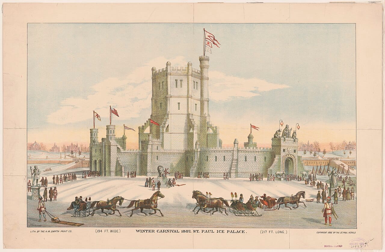
Pride or marketing, I can't say. It took the city's worst feature and made it an event, which is something you can walk up to and look at.
Fifty-four years later the weather came back, and nobody had sold a share in it.
Monday, 11 November 1940, Armistice Day. Down in the southeast the Weather Service says the day began with blue skies and temperatures in the forties and fifties, and by midday, Minnesota Public Radio reports, some areas there topped sixty. Norman Roloff, who was there, told Minnesota Public Radio sixty years afterward, "I recall it being quite warm." So hunters went out, dressed for a mild autumn day, which it was, for a few hours.
At the Twin Cities airport it was 34 degrees at seven in the morning and 15 by three in the afternoon. Nineteen degrees in eight hours. From noon until eleven that night you could see an eighth of a mile at best, about two football fields, and often less. The wind ran about thirty and gusted to 43 at 9:51 p.m. The Twin Cities got around sixteen inches, one state page says 16.2 and another 16.7. Twenty-foot drifts were reported near Willmar.
Forty-nine Minnesotans died, many of them hunters. The Weather Service counts twelve duck hunters trapped on the Mississippi between Saint Paul and Prairie du Chien. It counts 154 dead in all, 59 of them on Lake Michigan, though other counts put the lake higher. A pilot named Max Conrad, of Winona, flew a Piper Cub into fifty-mile-an-hour wind to drop supplies to stranded men. Roloff and a man named Sonny Ehlers lived. Ehlers remembered telling him, "Norm, we gotta make it, there's no alternative or we're going to be dead." The state climatologists call it the defining blizzard of the twentieth century in Minnesota.
In 1886 Saint Paul raised $5,210 in ten-dollar shares for a building that would melt, and got crowds. In 1940 the cold showed up unannounced and the bill came in bodies. It had no board and held no hearing. Nobody could condemn it, or rezone it, or move it to make room for something better.
The next thing that took people out of this city came with paperwork.
The Gateway
Stand at Hennepin and Washington, at the foot of what was the Gateway. A Four Seasons sits on the block where the Nicollet Hotel used to stand, and a Whole Foods opened at 222 Hennepin in 2013. On FOX 9, James Eli Shiffer, who wrote the book on what stood here, asked whether the place is the city it was, and answered it himself: "It's kind of bloodless."
About three thousand men lived in the district, give or take, depending on which count you trust. Most were single and aging, finished with the seasonal work that had brought them: railroad gangs they called gandy dancers, harvest crews, loggers. The historian Kirsten Delegard adds Chinese men who had left the West Coast to get away from racial violence, and Native Americans who wanted to be anonymous in a big city. FOX 9 counts more than sixty liquor stores, saloons and brothels in about twenty blocks. The men slept in hotels with names like the Pioneer, in rescue missions, in flophouses at fifty cents a night, and in cage rooms, cubicles of tin and plywood with chicken wire stretched across the top. A photo caption in the state's encyclopedia says that in 1953 there were ten men to every toilet. Larry Millett, writing in the Star Tribune, says most of them "were simply retired laborers struggling to get by on small pensions." The rest of the city had a lesson for its children. Shiffer writes that parents would drive down Washington Avenue with their kids and say, "If you don't stay in school and work hard, this is where you'll end up."
One man ran a bar, a liquor store and a cage hotel down there. John Bacich, called Johnny Rex, owned a Bell and Howell movie camera and took it out onto Washington Avenue to film the street. According to Shiffer, many of the portraits he took of his customers were shot through a square hole cut in a plywood wall, so that each man's head poked through. Earlier snapshots hung on the plywood above the sitter. Bacich sold these men their liquor. MinnPost reports that when his customers died without family, he paid to bury them, and the veterans went to Fort Snelling. FOX 9 has Shiffer calling him both an advocate for the men and their enabler. Among the notes he wrote on the backs of photographs: "Ted Evenson, A carpenter and a good one when sober!" and "A nice quiet sort of man." In his film, two railroad men from Indiana, Emil Teske and Nick Fiestal, wrestle on the sidewalk, each holding the other by the nose.
Gateway Park sat at the front of the district, just south of the river, with a Beaux Arts pavilion. The men sat in it, and a photograph from the Historical Society's collection carries the caption "Radical speakers in Gateway Park." The newspapers called it a "piss palace," FOX 9 reports, and Shiffer writes that the papers spent a decade campaigning to tear the district down, and "went to extraordinary lengths to display its degradation." One photographer, he says, supplied a drunk with a flashlight for his pocket and, probably, some money to "go get hammered." In 1953 the pavilion was torn down and a four-foot fence went up. Delegard says the Nicollet Hotel went up in 1924, built by a group of businessmen as a barrier between the "blighted" district and the better stores nearby. She compares it to a fortress, its brick walls looming over the park.
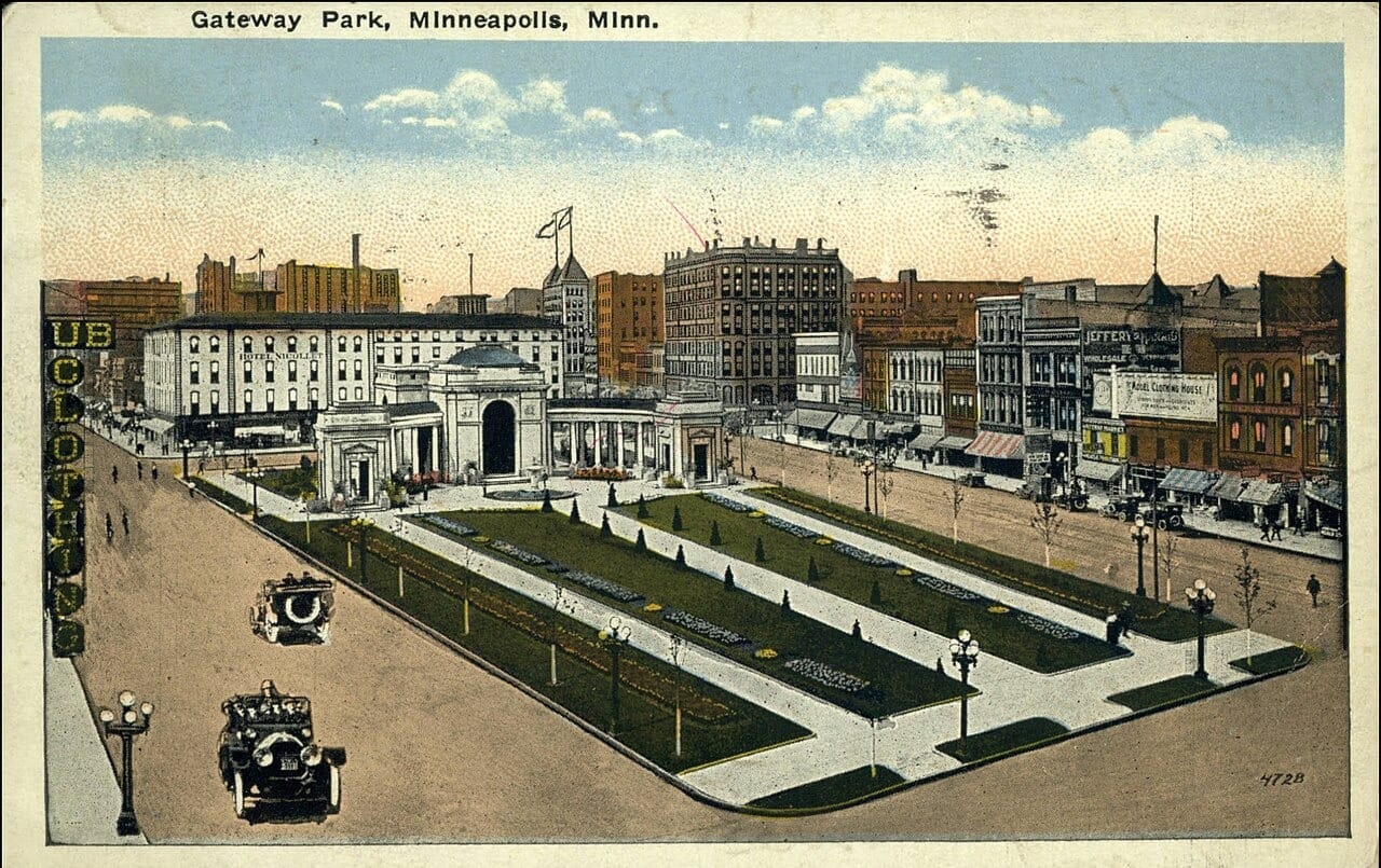
A 1956 Downtown Council document, Delegard writes, said the renewal plan sought to "increase the quantity and quality of people coming to" the Lower Loop, one of the names for the same ground. A report from the 1950s argued that clearance would "restore the health of the city," as "removing a clot from the bloodstream" restores a body. The clot was about three thousand men. Molly Jessup, of the Mill City Museum, says: "It's not necessarily about the safety of the city, it was about what does this say about our city, our image."
The first plan was to house the men in high-rises. By Shiffer's account in the Star Tribune no neighborhood would take them, and the City Council let the idea go. In 1959 a man who called himself Mr. Skid Row, John Ladzikowski, handed out flyers against moving the men to the site the city eyed to the north and west, in what is now the North Loop. "It's noisy, dusty, filled with dust and auto gas fumes," he wrote. The Council voted unanimously for the Gateway Center project, and Millett reads the newspapers of the day as showing little dispute over tearing the district down. The fight was over where the men would go. Jessup says: "Once the housing in The Gateway was removed there wasn't any place for them to go."
In archival news footage from 1958, by FOX 9's account, the head of the Housing and Redevelopment Authority sorted the men into two groups. About 1,650, he said, could "relocate themselves." For the other 1,255 he foresaw "a great problem facing them when the time comes for demolition." A man who found a new room got five dollars from the city if he told the city his new address. FOX 9 puts that at roughly fifty dollars today. Shiffer reports a 1963 survey that counted 2,427 permanent residents before clearance. Of those, 588 had left by the time the city started buying buildings. The two 1958 figures add up to 2,905, which does not match, and I could not reconcile them. The rest are believed to have scattered to Seven Corners, Nicollet Island and elsewhere, near soup kitchens and flophouses that outlasted the Gateway by about ten years. "In some cases," Jessup says, "people really disappeared from the historical record."
About two hundred buildings came down. FOX 9 puts it at 40 percent of downtown, the neighborhood association at a third, and the sources can't agree whether it took two years or five. The Metropolitan went in the same project, the one with the translucent floors, and Millett says it should have been saved. The cage hotels went, and the bars around them. The Nicollet Hotel, with its wall, got a dispensation from the planners and stood until 1991, nearly three decades after the men it looked down on were gone. In 2014 a council member named Jacob Frey called the hotel's block "arguably the sexiest parcel in the city."
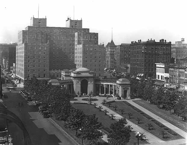
Millett writes that, in the context of the times, it would have been "very difficult" to have saved the Gateway, and Minneapolis had no preservation commission until 1971.
Evicted when the city cleared the blocks, Johnny took the pinned photographs down and carried them with him. They had been pinned and unpinned so many times that the corners wore away, and the pinholes show. In the 1980s he narrated his old footage, and Shiffer reports what he says over it: "Not a trace of it now." Shiffer went looking anyway. He found concrete walls with nothing on them, and asphalt parking.
Johnny was right.
Sources
Each note says which claim the source carries. Where two sources disagree, the text says so and both are listed. Pages that moved or could not be opened in my last pass are marked.
Bdote
- Dave Larsen, quoted in Sacred Land Film Project, "Bdote" (the epigraph; the place of creation). https://sacredland.org/bdote/
- Minnesota Historical Society, Historic Fort Snelling, "Bdote" (the name; the clay). https://www.mnhs.org/fortsnelling/learn/bdote
- Sheldon Wolfchild, quoted in Minnesota Historical Society, "Bdote," US-Dakota War of 1862 (2011). https://www.mnhs.org/usdakotawar/stories/history/dakota-homeland-land-lifestyle/bdote
- Minnesota Historical Society, "Minnesota Treaties" (Pike's gifts and valuation; the Senate's $2,000; Traverse des Sioux payment terms; Luke Lea at Mendota). https://www.mnhs.org/usdakotawar/stories/history/treaties/minnesota-treaties
- Treaties Matter, "Treaty with the Sioux, 1805" (the date; two of seven signers; liquor; never proclaimed; the 1856 Senate committee). https://treatiesmatter.org/treaties/land/1805-dakota
- Minnesota Historical Society, US-Dakota War of 1862: Timeline (the 1808 approval; the war's first days, 17 and 18 August 1862). https://www.mnhs.org/usdakotawar/timeline
- National Park Service, Mississippi National River and Recreation Area, "The Confluence" (posts at the confluence, the falls and the St. Croix; the cornerstone, 10 September 1820). https://home.nps.gov/miss/learn/historyculture/confluence.htm
- MNopedia, "Fort Snelling in the Expansionist Era, 1819-1858" (the 1819 arrival; construction from 1820; enslaved people at the fort, fifteen to thirty at a time; the Scotts). https://www.mnhs.org/mnopedia/search/index/place/fort-snelling-expansionist-era-1819-1858
- Smithsonian National Museum of American History, "Where Two Waters Come Together" (the Scotts at Bdote; the 1857 ruling on citizenship). The holding on Congress and the territories is from Dred Scott v. Sandford, 60 U.S. (19 How.) 393 (1857), which I have not linked. https://americanhistory.si.edu/explore/stories/where-two-waters-come-together-confluence-black-and-indigenous-history-bdote
- MNopedia, "Treaty of Traverse des Sioux, 1851" (the date; about 7.5 cents an acre; the traders' paper not read aloud or translated, taken for another copy) and "Treaty of Mendota, 1851" (the date; Pilot Knob). https://www.mnhs.org/mnopedia/search/index/event/treaty-traverse-des-sioux-1851 ; https://www.mnhs.org/mnopedia/search/index/event/treaty-mendota-1851
- Minnesota Historical Society, Traverse des Sioux, "Learn" (about 24 million acres; the reservation article struck; starving by 1862). https://www.mnhs.org/traversedessioux/learn
- Minnesota Historical Society, "The Traders' Paper" (about a third of cash payments; Sibley). https://www.mnhs.org/usdakotawar/stories/history/traders-paper
- U.S. Census Bureau, State Area Measurements (Indiana, 36,420 square miles). Twenty-four million acres is 37,500 square miles (computed). https://www.census.gov/geographies/reference-files/2010/geo/state-area.html
- Minnesota Historical Society, "Andrew Myrick" (credit refused when the annuity was late; the letter of 26 July 1862; the grass story given as tradition). https://www.mnhs.org/usdakotawar/stories/history/andrew-myrick ; the page points to Gary Clayton Anderson, "Myrick's Insult: A Fresh Look at Myth and Reality," Minnesota History (1983).
- Minnesota Historical Society, US-Dakota War of 1862, Frequently Asked Questions (settler deaths, "between four and six hundred"). https://mnhs.org/usdakotawar/frequently-asked-questions ; MNopedia, "US-Dakota War of 1862" ("more than 600 settlers"). https://www.mnhs.org/mnopedia/search/index/event/us-dakota-war-1862
- Minnesota Historical Society, "Alexander Ramsey" (9 September 1862; not in the prepared text). https://www.mnhs.org/usdakotawar/stories/history/alexander-ramsey
- Minnesota Historical Society, "The Trials & Hanging" (392, 303, 16; the increasing speed; Carol Chomsky; about 4,000 spectators; the sandbar grave; physicians before morning). https://www.mnhs.org/usdakotawar/stories/history/aftermath/trials-hanging
- Mayo and the skull: MPR News, "Mayo issues an apology 156 years in the making" (18 September 2018; William Mayo; Marpiya Okinajin; the skeleton; the skull on display until 1998). https://www.mprnews.org/story/2018/09/18/mayo-issues-an-apology-156-years-in-the-making ; Post Bulletin, Kiger (20 September 2018) (Jeff Bolton's apology on 31 August 2018, "our role in that broken relationship," via the Omaha World-Herald; two skulls returned in 1998, one confirmed; the skeleton's fate unknown).
- Minnesota Historical Society, "Forced Marches & Imprisonment" (about 1,700 from 7 November; Henderson; Samuel J. Brown's account; New Ulm; camp deaths from 102 to 300; Renville; Davenport, at least 120 dead). https://www.mnhs.org/usdakotawar/stories/history/aftermath/forced-marches-imprisonment
- MNopedia, "Fort Snelling in the Civil and US-Dakota Wars, 1861-1866" (about 1,600 held; 130 to 300 deaths). https://www.mnhs.org/mnopedia/search/index/place/fort-snelling-civil-and-us-dakota-wars-1861-1866
- MPR News, "Part 10: Payback for the Dakota: banishment" (2012; about 150 miles; Mary Wingerd). https://www.mprnews.org/story/2012/12/11/dakota-war-part10
- Minnesota Historical Society, "Exile" (the treaties abrogated, February and March 1863; Crow Creek). https://www.mnhs.org/usdakotawar/stories/history/aftermath/exile
- Minnesota Historical Society, "Bounties" (July scouts at $25; civilians at $75, raised to $200 in September; Little Crow's death and the $500; the scalp; the Society's exhibit until 1915; the burial in 1971). https://mnhs.org/usdakotawar/stories/history/aftermath/bounties
- ICT News, "Governor Walz makes historic apology for 1862 mass hanging in Mankato" (26 December 2019; "for what happened to the Dakota people"). https://ictnews.org/the-press-pool/governor-walz-makes-historic-apology-for-1862-mass-hanging-in-mankato
- Gary Clayton Anderson on "ethnic cleansing": New Ulm Journal (Busch, 16 November 2019). Only the ethnic cleansing remark is clear on that page. His line on the word genocide is garbled there, and the text says so.
- United Nations, Convention on the Prevention and Punishment of the Crime of Genocide, Article II (the definition, including "conditions of life calculated to bring about its physical destruction"). https://www.ohchr.org/en/instruments-mechanisms/instruments/convention-prevention-and-punishment-crime-genocide
- CBS Minnesota (2019) and Forum News Service (2022), on the signs, the funding threat, "public confusion" and the board vote. https://www.cbsnews.com/minnesota/news/fort-snelling-bdote-signs-lead-gop-to-threaten-minnesota-historical-societys-budget ; https://www.inforum.com/news/minnesota/minnesota-historical-society-nixes-renaming-historic-fort-snelling
- KSTP, "Historic Fort Snelling reopens, focus on pride and pain of site" (31 May 2022; $34.5 million). https://kstp.com/?p=2233713
- National Park Service, "Mni Ówe Sni / Coldwater Spring" (Traditional Cultural Place, 3 November 2023). https://www.nps.gov/places/mni-owe-sni.htm
The Falls
- National Park Service, Mississippi National River and Recreation Area, River of History, chapter 6 (the Dakota names for the falls; Kakabikah as the Ojibwe name for the limestone blocks below; Carver and Spirit Island; Schoolcraft and the NPS reply; the soldiers' mills, 1821 to 1823; 157 squatters; Plympton's boundary; the Palmyra, 15 July 1838; Steele's claim; Hole-in-the-Day at 50 cents a tree; $12,000; title in 1848; the west bank, 1852 to 1855; the 1856 charters; sawmill output; clear-cutting; the tunnel and the witness; the flour process, the southern Minnesota millers and the 1870s rollers; 1880 as the top milling year). https://home.nps.gov/miss/learn/historyculture/river-of-hisory-chapter-6.htm (the URL is spelled that way on the Park Service's site)
- Star Tribune, on Spirit Island and its quarrying, citing John Anfinson (a sixth left by 1899; gone by 1963). https://www2.startribune.com/minneapolis-spirit-island-dakota-history/600298046/
- McKnight Foundation, "Revitalizing and healing Minnesota's sacred riverfront" (16 January 2026; Shelley Buck; the former width of the falls, 1,250 feet). https://www.mcknight.org/news-ideas/revitalizing-healing-minnesotas-sacred-riverfront/
- Northeaster, Cynthia Sowden, "Danger ahead: Saving St. Anthony Falls" (24 September 2025) (1,500 feet then and about 350 now; $615,000 between 1870 and 1880). The Corps gives 1885 as the end year and a wall 1,850 feet long. The Northeaster gives 1,570 feet. The text follows the Corps. https://www.mynortheaster.com/news/danger-ahead-saving-st-anthony-falls/
- MNopedia, "Steele, Franklin" (revised 2025; "war profiteer"; the $90,000 for Fort Snelling; Rice's notice in 1857; $30,000 in checks sent to Rice; Sibley, his brother-in-law; the sutler from about 1838). https://www.mnhs.org/mnopedia/search/index/person/steele-franklin-ca.-1813-1880 ; MNopedia, "Rice, Henry Mower" (territorial delegate from 1853; senator at statehood in 1858). https://www.mnhs.org/mnopedia/search/index/person/rice-henry-mower-1816-1894
- MNopedia, "October 5, 1869: St. Anthony Falls Tunnel Collapses" (the cavern; Brackett directing the cofferdams with the fire department; hundreds of volunteers; the partners' purchase of much of Nicollet Island). The old minnpost.com and mnopedia.org links no longer resolve. https://www.mnhs.org/mnopedia/search/index/event/st-anthony-falls-tunnel-collapse-october-5-1869
- U.S. Army Corps of Engineers, St. Paul District, Jane Lamm Carroll, "Engineering the Falls" (27 October 2015) (the $50,000; Franklin Cook's navigation argument; the dike built 1874 to 1876, 1,850 feet long and 40 feet deep; the apron and dams to 1880; $615,000 between 1870 and 1885). The page gives no day for the appropriation. https://www.mvp.usace.army.mil/Media/News-Stories/Article/626089/engineering-the-falls-the-corps-of-engineers-role-at-st-anthony-falls/
- Friends of the Mississippi River, Colleen O'Connor Toberman (14 August 2026), on the cutoff wall study (no evidence of impending failure; ownership not settled; 40 feet tall, over 1,800 feet long). Also the study itself, St. Anthony Falls Study (1 July 2026), https://www.lrl.mn.gov/docs/2026/mandated/261060.pdf
- MNopedia, "Washburn Mill Explosion, 1878." https://www.mnhs.org/mnopedia/search/index/event/washburn-mill-explosion-1878 . The page gives 1885 for the Lakewood Cemetery monument to the eighteen men and does not say who put it up, so the text does not say.
- MNopedia, "Minneapolis Flour Milling Industry during World War I" (18.5 million barrels; over 20 percent; the three firms). https://www.mnhs.org/mnopedia/search/index/thing/minneapolis-flour-milling-industry-during-world-war-i ; Mill City Museum, timeline (the A Mill, 1874; 1880; 1965; 2003). https://www.mnhs.org/millcity/learn/history/timeline ; Mill City Museum, "Minneapolis Flour Milling Boom" (Buffalo takes over in 1930; the A Mill closed in 1965). https://www.mnhs.org/millcity/learn/history/flour-milling ; Mill City Museum, "The Building" (closed 1965; burned in February 1991). https://www.mnhs.org/millcity/learn/history/building
- MNopedia, "Minneapolis Flour Mill Strike, 1903" (about 1,300 at the meeting; the pay demand for women; 24 September; fourteen mills halted; the strikebreakers' inducements). https://www.mnhs.org/mnopedia/search/index/event/minneapolis-flour-mill-strike-1903 ; Barb Kucera, University of Minnesota Labor Education Service, "Chronology of Minnesota Workers and their Organizations" (2008) (1,800 strikers; "a huge boost" for the Citizens Alliance; the 1934 strikers breaking its back). https://minneapolis1934.umn.edu/sites/minneapolis1934.umn.edu/files/2024-10/mn_labor_history_timeline_2008.pdf
- MPR News, Matt Sepic (10 June 2015), on the closing of the Upper St. Anthony Falls lock (the last boats on Tuesday night, 9 June; the carp; the Corps still running the lock for flood control). https://www.mprnews.org/story/2015/06/10/upper-st-anthony-falls-lock-closes
- Sahan Journal, "St. Anthony Falls, Owámniyomni, Mississippi River restoration" (Owámniyomni Okhódayapi; construction; the delayed transfer). https://sahanjournal.com/climate-environment/st-anthony-falls-owamniyomni-mississippi-river-restoration/ . The 2020 order to hand the land over and the April 2025 designation rest on CBS Minnesota reporting from April 2025.
- ENTER, Cinnamon Janzer, "Water Works Park Pavilion" (2 May 2022) (the pavilion built on the foundations of the Bassett, Occidental and Columbia mills; Owamni called "Minnesota's first full-service Native American restaurant"). https://www.entermn.com/articles/water-works-park-pavilion ; Owamni, press release of 1 October 2025 (the move to the Guthrie in spring 2026). https://owamni.com/blog/owamni-to-relocate-in-2026-to-guthrie-theater-restaurant-space/ ; Mpls.St.Paul Magazine, 21 April 2026 (Owamni due to vacate at the end of April; Arch and River, a French bistro, named for the space; no opening date) https://mspmag.com/eat-and-drink/foodie/new-restaurant-replacing-owamni-bberi-desserts-arch-river/ ; Mpls.St.Paul Magazine, 15 July 2026 (Indígena by Owamni open at the Guthrie, the Water Works spot now "former") https://mspmag.com/eat-and-drink/foodie/indigena-by-owamni-guthrie-theater-opening-minneapolis-restaurant/
The Landing
- National Park Service, Mississippi National River and Recreation Area, "Lambert's Landing" (I-mni-za ska dan; the Lower Landing at Jackson Street; renamed 1937; removed in the 1950s for Warner Road; 1,068 arrivals in 1858). https://www.nps.gov/miss/planyourvisit/lambland.htm
- National Park Service, River of History, chapter 4 (41 arrivals in 1844, 95 in 1849, 965 in 1857, 1,090 in 1858 by 62 boats). https://www.nps.gov/miss/learn/historyculture/river-of-history-chapter-4.htm . The Park Service's own two pages differ on 1858 (1,068 and 1,090), and the text gives both. Clio, the Minnesota Historical Society's entry on the landing (one of the busiest steamboat landings). https://theclio.com/tour/1463/5
- Parrant: Goff, Ramsey County History 56:1 (Spring 2021). https://rchs.com/wp-content/uploads/2021/05/RCHS_Spring-2021_Goff.pdf ; MNopedia, "This Day" entries (the squatter, the army's clearing, the chapel of 1841). Kunz (1991) on the capital's naming. The embellished legend is attributed in the text to the writer who told it.
- American Heritage, Jack El-Hai, "The Census War" (July/August 1990) (the population of Minneapolis in 1880; Stevens and the Bureau of Information; Smith; Mason and the invented families; the 7 June affidavit; the 17 June arrests; the police scene; Porter's counts; the depot, plant, house and barbershop; the indictments of 33; the Jezebel editorial; the $15,000 loss tied to the arrests and boycott). https://www.americanheritage.com/census-war
- MNopedia, "Eliza Winston Court Case" (the Winslow House; the 21 August 1860 ruling; the courthouse crowd; her departure). https://www.mnhs.org/mnopedia/search/index/event/eliza-winston-court-case
- William D. Green, Children of Lincoln (University of Minnesota Press, 2018) (the Davenport, 4 May 1863; the crowd). I could not open the online edition when I checked, so every claim that rests on it alone is attributed to the St. Paul Press through the Williamson letter (note 7), or left out. https://manifold.umn.edu/read/d6cfd5c8-9426-4e21-b5f1-19adecc652c1/section/ecf3bea4-4453-4fea-b5d4-60d8b736d29a
- John P. Williamson, letter of 13 May 1863, in "Removal of the Sioux Indians from Minnesota," Minnesota History 2:6 (May 1918), with Frances Relf's notes (the Northerner with 540, against 334 in the St. Paul Press of 6 May; 770 on the first boat in Williamson's letter against 762 in the St. Paul papers; the soldier wounded at Birch Coulee; "boulders"; the women struck). https://storage.googleapis.com/mnhs-org-support/mn_history_articles/2/v02i06p420-425.pdf ; MNopedia, "Fort Snelling in the Civil and US-Dakota Wars, 1861-1866." https://www.mnhs.org/mnopedia/search/index/place/fort-snelling-civil-and-us-dakota-wars-1861-1866
- National Park Service, "Reverend Robert Hickman" (the raft; the Irish laborers; the diversion to Fort Snelling; the St. Paul Press line, as the Park Service prints it). https://home.nps.gov/people/reverend-robert-hickman.htm
- MNopedia, "Rolette, Joseph, 1820-1871" (the claim that he saved the capital "is untrue"; the bill; the judge's ruling; the petition "during the following summer"). https://www.mnhs.org/mnopedia/search/index/person/rolette-joseph-1820-1871 ; Minnesota Legislative Reference Library, https://www.lrl.mn.gov/docs/2009/other/090951.pdf ; Witt, Minnesota Territorial Pioneers (mnterritorialpioneers.org).
- MNopedia, "West Side Flats, St. Paul" (the neighborhood; the 1952 flood; the 1956 industrial park; the 1961 count of 480 buildings and 2,147 people; the end of 1963). https://www.mnhs.org/mnopedia/search/index/place/west-side-flats-st-paul ; MPR News, Vicki Adame (30 March 2022) (the last families gone by 1962, which differs). https://www.mprnews.org/story/2022/03/30/former-west-side-flats-residents-have-mixed-memories-about-their-old-neighborhood ; Sahan Journal, Katelyn Vue (3 September 2024) (the roughly $4 million floodwall; the report's counts; Mayor Carter's proposal). The page does not say what became of the proposal.
- West Side Community Organization, gallery and Inheritance Fund post (13 August 2024) (George Avaloz; the proposal to extend down payment assistance to descendants). https://www.wsco.org/wsflatsgallery ; https://www.wsco.org/westsideinheritancefund
The Car Line
- MNopedia, "Twin City Rapid Transit Company and Electric Streetcars" (the horsecars on 2 September 1875; the first electric lines, 24 December 1889 and February 1890; Como-Harriet in 1898, 17 miles, 10 cents; Selby-Lake in 1906; 238 million riders in 1920; all horsecar lines converted by 1892; more than 900 cars on more than 523 miles of track in the 1920s). https://www.mnhs.org/mnopedia/search/index/thing/twin-city-rapid-transit-company-and-electric-streetcars
- MNopedia, "Lowry, Thomas" (president 1878 to 1909; the land motive; more than a third of the property in Minneapolis). https://www.mnhs.org/mnopedia/search/index/person/lowry-thomas-1843-1909
- Twin Cities Streetcars primary source set, Minnesota Digital Library (ridership down 48 percent, 1920 to 1932). https://mndigital.org/node/428
- Star Tribune, "A few facts about Twin Cities trolleys" (a nickel in 1900; a dime in 1929; "more than 238 million" riders and 652,000 a day in 1920; "more than 520 miles" of track). Metropolitan Council budget document (Metro Transit, about 77 million rides in 2019). https://www.lrl.mn.gov/docs/2021/Mandated/210126/metropolitan-council-transportation.pdf
- Xie and Levinson, "How streetcars shaped suburbanization," Journal of Economic Geography 10(3), 2010 (density; the half-mile finding). https://ideas.repec.org/a/oup/jecgeo/v10y2010i3p453-470.html
- "Minneapolis in the Age of Grade Separation," historical marker (3,500 multi-family dwellings). https://www.hmdb.org/m.asp?m=240652 ; Lake Street Station marker (180 cars, 500 employees, 1910). https://www.hmdb.org/m.asp?m=134460
- J. Biber, "Take a ride aboard the trolleys of Southwest Minneapolis," The Minnesota Historian (2022) (the Lake and Hennepin node; the Como-Harriet entering at Lagoon and Hennepin), citing Diers and Isaacs, Twin Cities by Trolley. https://www.minnesotahistory.org/post/take-a-ride-aboard-the-trolleys-of-southwest-minneapolis
- MNopedia, "Twin Cities Streetcar Strike, 1917" (Linda A. Cameron) (the 57 firings; the walkout of 6 October; the six hundred deputies; forty-nine returning; the company union and its buttons; the ban on buttons for both sides; the Home Guard; the general strike of 13 December lasting under four hours). https://www.mnhs.org/mnopedia/search/index/event/twin-cities-streetcar-strike-1917 . I cut a quotation from Mary Wingerd that I could not find in the MinnPost piece or anywhere else I could open.
- MNopedia, "Racial Housing Covenants in the Twin Cities" (Kirsten Delegard) (the Scott sale, 26 May 1910; the Seven Oaks Corporation and "thousands of deeds"; the clause). https://www.mnhs.org/mnopedia/search/index/thing/racial-housing-covenants-twin-cities
- Petersen and Delegard, "Race and the streetcar suburb," Mapping Prejudice (15 November 2021) (Shenandoah Terrace, 327 lots; the Chicago Avenue line past Minnehaha Creek; the orphan asylum as landowner). https://mappingprejudice.umn.edu/test/story/race-streetcar-suburb
- Ehrman-Solberg et al., "Racial Covenants in Hennepin County," University of Minnesota Data Repository (24,119 lots; 1910 to 1955). The counts by year, by deed and by city are computed from the dataset. A row is a lot, and there are about 13,000 distinct deeds. https://conservancy.umn.edu/items/16b494dc-ef78-4cbf-90b3-40ebe886c13f
- Mapping Inequality, University of Richmond Digital Scholarship Lab (HOLC grades, 1935 to 1940), through the Bunk History partner page, "Mapping Inequality" (the red grade; "infiltration"). https://bunkhistory.org/resources/mapping-inequality-redlining-in-new-deal-america . The Mapping Inequality site itself would not open for me, so the text makes no claim about the Minneapolis map.
- MNopedia, "Motorettes" (105 million to nearly 194 million; 381 motorettes). https://www.mnhs.org/mnopedia/search/index/group/motorettes ; Minnesota Streetcar Museum, "Museum History" (141 streamlined cars). https://trolleyride.org/?p=1095
- Minnesota Department of Highways and U.S. Bureau of Public Roads, The Role of Mass Transit: Twin Cities Metropolitan Area (March 1963) (the 1949 and 1958 trips in the 1949 study area; 26.4 and 12.7 percent; shopping 28.3 to 8.6 percent; 69,000 of 408,000 dwelling units without a car in the 1958 study area; school buses in the 1958 count). https://mdl.mndot.gov/_flysystem/fedora/2024-09/role-of-mass-transit-1963.pdf
- Isaacs v. United States, 301 F.2d 706 (8th Cir. 1962) (the opinion spells the name Blumenfield; he is better known as Isadore Blumenfeld; Green's election; the proxy campaign; Ossanna's presidency; Blumenfield as friend and close business associate and real owner of shares; the conversion sentence; six defendants on seventeen counts, thirteen to the jury; the verdict of 6 August 1960; the scheme "to loot the Transit Companies"; the cable, Mexico City and Hopkins figures; the sentences). https://law.resource.org/pub/us/case/reporter/F2/301/301.F2d.706.16655.16656.16662.16663.16669.html ; MNopedia, "Blumenfeld, Isadore" (the acquittal; Kid Cann).
- D. Levinson, "Twin Cities Rapid Transit, Southwest LRT, and Prospect Theory," streets.mn (2014) (Green's firings; the $7.9 million purchase, with no citation given). https://streets.mn/2014/03/10/twin-cities-rapid-transit-southwest-lrt-and-prospect-theory/
- K. Delegard, "Streetcars in Minneapolis: Now and Then," Historyapolis (19 June 2013) (the 525 buses and General Motors' liberal terms; the burned cars). https://static.lib.umn.edu/publishing/historyapolis/wp-json/wp/v2/posts/297/index.html
- V. B. Kunz, Ramsey County History (Spring 1970) (the last Saint Paul cars). https://rchs.com/wp-content/uploads/2015/11/RCHS_Spring1970_Streetcars.pdf ; Edina Magazine, "Last Streetcar Ride in Edina" (18 June 1954). The page would not load when I tried it in October 2026 (a certificate error), so the text gives only the month and year. https://archive.edinamag.com/node/8132
- Minnesota Historical Society, "Minneapolis farewell to streetcars" (the 1954 photograph; Ossanna and the window). https://mnopedia.org/multimedia/minneapolis-farewell-streetcars
- Star Tribune, "Curious Minnesota" (Diers and Isaacs on the "urban legend"). https://www.startribune.com/040421-curious-minnesota/600020578/ ; L. Guilbault, "The Conspiracy Revisited Rebutted," Electric Railway Historical Association (Larrick and National City Lines; GM not involved in this conversion). An advocacy source. https://www.erha.org/plot2.htm
The Tower
- Google Patents, US 383,170, "Iron Building Construction," L. S. Buffington (issued 22 May 1888; "composed chiefly of iron"; posts of "any desired height"). https://patents.google.com/patent/US383170
- MNopedia, "Buffington, Leroy Sunderland" (the $30,000; the controversy that "died down without a clear resolution"). The old URL moved to the Historical Society's site. https://www.mnhs.org/mnopedia/search/index/person/buffington-leroy-sunderland-1847-1931
- Jason M. Barr, "The Jenney Myth (Part II)," Building the Skyline (2024) (no building built on the system). https://buildingtheskyline.org/?p=6765
- Jerry Larson, "3.13 Buffington's Cloudscraper," The Architecture Professor (28 stories, 350 feet, Inland Architect of July 1888; the Building Record and Architectural News quotations). This is course material without footnotes, so the periodicals' own issue dates are unverified and the text says it has them secondhand. https://thearchitectureprofessor.com/2021/03/30/3-13-buffingtons-cloudscraper
- Axios Twin Cities (22 May 2023) (the $2,250 royalty, paid voluntarily by the developer of the Rand Tower; the $30,000 spent). https://www.axios.com/local/twin-cities/2023/05/22/minnesotan-leroy-buffington-patented-skyscraper-1888
- Hennepin History Museum, John Crippen, "A Fantasy in Iron" (Mix and Menage; 8,000 guests; Metropolitan Life in 1905; the September 1961 statement and the ninety days; Bliss). https://hennepinhistory.org/a-fantasy-in-iron/ ; Larry Millett, "Ghost of the Gateway," Minnesota History 53:3 (Fall 1992) (the opening on 31 May 1890; twelve stories; wrecking trucks on 18 December 1961). https://storage.googleapis.com/mnhs-org-support/mn_history_articles/53/v53i03p112-115.pdf
- Larry Millett, Metropolitan Dreams (University of Minnesota Press, 2018), publisher description ("the tallest, largest, and most splendid commercial structure in Minneapolis"). https://www.combinedacademic.co.uk/9781517904166/metropolitan-dreams
- Star Tribune, Rick Nelson, "They paved paradise" (11 December 2011) (condemnation from May 1959; the 31 October eviction; the dates of demolition; $32,000; the parking lot; Cerny's letter, written in defense of the Authority; Progressive Architecture; Morrison). https://www.startribune.com/they-paved-paradise/135285333
- City of Minneapolis, 2013 Heritage Preservation Commission Annual Report (the commission created in 1971). https://www.minneapolismn.gov/media/-www-content-assets/documents/2013-Heritage-Preservation-Commission-Annual-Report.pdf
- MinnPost, "A century later, Minneapolis' failed city plan still resonates" (December 2017) (the 1917 plan; Crawford; "infested by skyscrapers"; the 500,000; almost a decade; at least four of eleven committee members dead; "almost none of its recommendations ever got adopted"). https://www.minnpost.com/politics-policy/2017/12/century-later-minneapolis-failed-city-plan-still-resonates ; Canadian Centre for Architecture, library record (Bennett and Crawford; 1,000 copies, September 1917). https://www.cca.qc.ca/en/search/details/library/publication/236320191
- MNopedia, "Foshay Tower" and "Foshay, Wilbur" (32 stories, about 447 feet; the Washington Monument memory, as Foshay told it; the three-day dedication, 30 August to 1 September 1929; $126,894 for the dedication; the name in ten-foot letters; the bounced check and Sousa's ban; the pardon; "charged"). The old mnopedia.org links no longer resolve. https://www.mnhs.org/mnopedia/search/index/structure/foshay-tower ; https://www.mnhs.org/mnopedia/search/index/person/foshay-wilbur-1881-1957
- U.S. District Court, District of Minnesota, historical exhibit, "Foshay," Parts 1 and 3 (25,000 at the dedication; $3.75 million; the bounced check; the receivership on 1 November 1929; the conviction on four of seventeen counts on 21 March 1932; fifteen years each; leaving the Ramsey County jail for Leavenworth on 5 May 1934; the commutation; the pardon). https://www.mnd.uscourts.gov/sites/mnd/files/Foshay01.pdf ; https://www.mnd.uscourts.gov/sites/mnd/files/Foshay03.pdf
- U.S. Marine Band, "Foshay Tower Washington Memorial" (the march recycled from one for the college in Denton; Sousa's withdrawal; the performance on 23 August 1976, "nearly forty-seven years" later). https://www.marineband.marines.mil/Audio-Resources/The-Complete-Marches-of-John-Philip-Sousa/Foshay-Tower-Washington-Memorial/ . A composers' radio program dates the revival to 1988, and I did not resolve it.
- Downtown Minneapolis Neighborhood Association, Foshay Tower signage (each floor four inches smaller; the apartment on the twenty-seventh floor; the IDS Center in 1972). https://www.thedmna.org/historic-signage/foshay-tower/ ; Twin Cities Business (the crowd as invitation list; "more than $120,000"). SAH Archipedia pages for the Foshay and the IDS Center sit behind a bot check and I could not read them.
- Minnesota Historical Society, Minnesota State Capitol, "Building History" (opened 2 January 1905; $4.5 million; groundbreaking 6 May 1896). https://www.mnhs.org/capitol/learn/building
- Marjorie Pearson, "Approaching the Capitol," Minnesota History (Winter 2016-17) (the state and the city both buying land; the clearance from 1950 and the work largely complete by 1955; 75 structures; the boulevards without the classical buildings; Park Place and Interstate 94). https://mn.gov/caapb/assets/10.%20MN%20State%20Capitol%20Mall%20history%20-%20Pearson%20Article%202017_tcm1087-573745.pdf ; Jo Blatti, The Minnesota State Capitol Area (1987) (Gilbert's lobbying, 1902 to 1931; the building "virtually unchanged"). The PDF is 133 pages and would not finish loading in my last check, so I did not re-verify "virtually unchanged" there; 1902 to 1931 is corroborated by Pearson. https://www.lrl.mn.gov/docs/2009/other/091089.pdf
Winter
- Bob Olsen, "Another Siberia, Unfit for Human Habitation: Saint Paul's Super Ice Palaces 1886, 1887, 1888," Ramsey County History 52:4 (Winter 2018) (the Siberia story's only citation; Montreal's cancellation; the Ryan Hotel meeting of 2 November; the shares; the palace; the crowd and the fence). https://rchs.com/wp-content/uploads/2018/01/RCHS_Winter2018_Olson.pdf
- Saint Paul Winter Carnival, "Origins of the First Winter Carnival" and "Palaces" (the line applied to Minnesota in general). https://www.wintercarnival.com/p/traditions--the-legend/history/origins-of-the-first-winter-carnival ; https://www.wintercarnival.com/p/traditions--the-legend/history/palaces
- Ramsey County Historical Society, "Winter Carnival Ice Palaces" (2023; the Central Park site; the dimensions). https://rchs.com/?p=18846
- Minnesota DNR State Climatology Office, "75th Anniversary of the Armistice Day Blizzard" and "#2: Armistice Day Blizzard" (34 degrees at 7 a.m. and 15 by 3 p.m.; visibility under an eighth of a mile from noon to 11 p.m.; the 43 mph gust at 9:51 p.m.; 16.2 and 16.7 inches; 49 dead, many of them hunters; the drifts near Willmar; "the defining blizzard"). https://dnr.state.mn.us/climate/journal/armistice_day_blizzard.html ; https://climateapps.dnr.state.mn.us/doc/journal/top5/numbertwo.htm
- National Weather Service La Crosse, "Armistice Day Storm" (blue skies and the forties and fifties; twelve duck hunters trapped between Saint Paul and Prairie du Chien; 154 dead in all, 59 on Lake Michigan). https://www.weather.gov/arx/nov111940
- Mark Steil, "The Winds of Hell," MPR News (10 November 2000) (Roloff; Ehlers; some southeast Minnesota areas above 60 by midday; the 66 sailors lost on the lake). https://www.mprnews.org/story/200011/10_steilm_blizzard-m
- MNopedia, "This Day: 11 Nov 1940" (Max Conrad). The old URL has moved. https://mnopedia.org/node/10540
- Minnesota DNR, "Twin Cities normals: 1991-2020 compared to 1981-2010" (the January mean of 16.2 degrees; 51.2 inches of snow); National Centers for Environmental Information, Minneapolis-St. Paul station normals, means and extremes (minus 34 in January 1970 as the low for the airport station since 1938). https://dnr.state.mn.us/climate/journal/twin-cities-normals-1991-2020-compared-1981-2010.html ; https://files.dnr.state.mn.us/natural_resources/climate/summaries_and_publications/2022kmsp.pdf . The DNR's streak page also lists a minus 41 in 1888 for downtown, which the text does not use.
The Gateway
- FOX 9, Lyden, "Minnesota Untold: The Unwanted" (7 November 2022) (Shiffer's "It's kind of bloodless"; the Four Seasons; the sixty-plus establishments; "piss palace"; the 1953 pavilion and fence; the 1958 footage and the 1,650 and 1,255; the $5; Jessup's three quotes; "advocate" and "enabler"; "obliterate your history"; more than 200 buildings; forty percent of downtown; Bacich's narration in the 1980s). https://www.fox9.com/news/minnesota-untold-the-unwanted-lessons-from-the-gateway
- Kirsten Delegard, "'The Gateway' Revisited," Historyapolis (9 February 2015) (the Nicollet Hotel of 1924 and its wall; the Downtown Council of 1956; the "clot" report; the dispensation; the hotel standing until 1991). https://historyapolis.com/2015/02/09/gateway-revisited/index.html
- Kirsten Delegard, "Looking for the lost Gateway District of Minneapolis," Historyapolis (1 June 2015) (Chinese men and Native Americans among the residents; the photograph of radical speakers in the park). https://historyapolis.com/2015/06/01/looking-for-the-lost-gateway-district-of-minneapolis/index.html
- James Eli Shiffer, excerpt from The King of Skid Row, TPT Originals (3 May 2021) (the main source for the Bacich paragraphs and the close; the "decade-long crusade"; the photographer and the flashlight; the plywood wall and the pinned pictures; "Ted Evenson" and "A nice quiet sort of man"; Teske and Fiestal; "Not a trace of it now"; the blank concrete walls). https://www.tptoriginals.org/step-into-the-hall-of-reflections-that-was-skid-row-circa-the-late-1950s/
- James Eli Shiffer, "Streetscapes," Star Tribune (27 May 2016) (the parents' lesson; the flophouses and cage rooms; Ladzikowski's flyer; the 1963 survey, 2,427 and 588; the $5; Seven Corners and Nicollet Island). https://www.startribune.com/streetscapes-living-in-downtown-minneapolis-was-a-badge-of-shame-in-the-days-of-the-gateway/381120751
- Larry Millett, "Minneapolis' notorious Gateway District was razed almost 60 years ago," Star Tribune (25 November 2017) (retired laborers; no real controversy; the unanimous vote; "very difficult"; the Metropolitan "should have been preserved"; the commission of 1971; nearly 200 buildings). https://www.startribune.com/minneapolis-notorious-gateway-district-was-razed-almost-60-years-ago-it-s-time-to-stop-mourning-its/459751913
- Amy Goetzman, on James Eli Shiffer's The King of Skid Row, MinnPost (25 April 2016) (Bacich paying to bury customers who died without family; the veterans at Fort Snelling). https://www.minnpost.com/books/2016/04/james-eli-shiffer-raises-ghosts-downtown-minneapolis-king-skid-row/
- Downtown Minneapolis Neighborhood Association, "Gateway District" (the pavilion; one-third of downtown; over two hundred buildings). https://www.thedmna.org/historic-signage/gateway-district/ ; MNopedia, "Gateway District ('Skid Row'), Minneapolis" (the caption of ten men to every toilet in 1953; the unanimous council vote). https://www.mnhs.org/mnopedia/search/index/place/gateway-district-skid-row-minneapolis
- Eric Roper, Star Tribune (16 October 2014) on the Nicollet Hotel block (Jacob Frey calling the block "arguably the sexiest parcel in the city"). Historyapolis, in the post cited above, reports the line without "arguably," and the text follows the Star Tribune. https://www.startribune.com/article/279367312
- Four Seasons Minneapolis, "Getting here" (245 Hennepin Avenue). https://www.fourseasons.com/minneapolis/getting-here/ ; CBS Minnesota, on the opening of the Whole Foods at Hennepin and Washington (September 2013). https://www.cbsnews.com/minnesota/news/whole-foods-opens-its-doors-in-downtown-mpls ; North Loop directory, Whole Foods at 222 Hennepin Avenue. https://northloop.org/directory/business/whole-foods-hennepin/ ; Hotel Online (6 April 2016), on the Four Seasons and the makeover of the Nicollet Hotel block. https://www.hotel-online.com/news/developers-say-theyre-working-with-four-seasons-on-tower-at-end-of-nicollet
Images
Every image here is listed as public domain on Wikimedia Commons. Three are cropped: the steamboat and Washburn A Mill stereo pairs to their left frames, and the Gateway Park postcard to its front. The Hennepin County Library items carry Commons' standard warning that they may not be public domain outside the United States. The library's own records say the five Hennepin County Library items are public domain in the United States, which is the claim the captions make. The Library of Congress records for the Vachon streetcar, the HABS interior and the ice palace were behind a bot check when I tried them, so for those three the rights basis is the Commons listing alone, and I have not read the Library of Congress records myself.
- Bdote. John Caspar Wild, Fort Snelling, watercolor, about 1844. Minnesota Historical Society collection, via Wikimedia Commons. Public domain. https://commons.wikimedia.org/wiki/File:Fort_Snelling_1844-Af000248.jpg
- The Falls. Seth Eastman, The Falls of St. Anthony, 1848. Minneapolis Institute of Art, accession 2009.16.1. Public domain. https://commons.wikimedia.org/wiki/File:Seth_Eastman_-_The_Falls_of_St._Anthony_-_2009.16.1_-_Minneapolis_Institute_of_Arts.jpg
- The Falls. Edward A. Bromley, Spirit Island with the Tenth Avenue Bridge in the Background, 1898. Hennepin County Library, via the Minnesota Digital Library and DPLA. Public domain in the United States. https://commons.wikimedia.org/wiki/File:Spirit_Island_with_the_Tenth_Avenue_Bridge_in_the_Background_-_DPLA_-_ea056ea4d3717b5f113eeb77903e9042.jpg
- The Falls. Washburn 'A' Mill Wreckage Following the Great Explosion of 1878 (left frame of a stereo pair shown), 1878. Hennepin County Library, via the Minnesota Digital Library and DPLA. Public domain in the United States. https://commons.wikimedia.org/wiki/File:Washburn_%27A%27_Mill_Wreckage_Following_the_Great_Explosion_of_1878_-_DPLA_-_8652ba83ab77f8b296683cbcb89d9324.jpg
- The Landing. William H. Illingworth, Steam Boat "Minneapolis" at Levee, St. Paul (stereograph, left half shown), 1867. Hennepin County Library, via the Minnesota Digital Library and DPLA. Public domain in the United States. https://commons.wikimedia.org/wiki/File:Steam_Boat_%22%22Minneapolis%22%22_at_Levee%2C_St._Paul_-_DPLA_-_8d57f8af1bcb4d2558618975ab955b03.jpg
- The Car Line. John Vachon, Streetcar, Minneapolis, Minnesota, 1939. Farm Security Administration, Library of Congress, digital ID fsa 8a04719. Public domain. https://commons.wikimedia.org/wiki/File:Streetcar-Minneapolis-1939.jpg
- The Tower. Sweet Studios, Northwestern Guaranty Loan Building, 1898. Hennepin County Library, via the Minnesota Digital Library and DPLA. Public domain in the United States. https://commons.wikimedia.org/wiki/File:Northwestern_Guaranty_Loan_Building_-_DPLA_-_6f7bd05e5aedd19b14e258458842103f.jpg
- The Tower. Interior of the Metropolitan Building, Minneapolis. Historic American Buildings Survey (HABS MN-49), Library of Congress. Public domain. The photographer and date given on Commons (Jack E. Boucher, November 1960) could not be confirmed. https://commons.wikimedia.org/wiki/File:Metropolitan_Building_skylight_Minneapolis.jpg
- Winter. H. Brosius, Winter carnival 1887: St. Paul ice palace, chromolithograph, H.M. Smyth Print Co., copyright 1886. Library of Congress, LCCN 2004672439. Public domain. https://commons.wikimedia.org/wiki/File:Winter_carnival_1887_-_St._Paul_ice_palace_(194_ft._wide)_-_(217_ft._long)_-_H._Brosius_%3B_lith._by_The_H.M_Smyth_Print_Co._LCCN2004672439.jpg
- The Gateway. Gateway Park, Minneapolis, postcard postmarked 23 May 1922 (front only shown). Hennepin County Library, via the Minnesota Digital Library and DPLA. Public domain in the United States. https://commons.wikimedia.org/wiki/File:Gateway_Park%2C_Minneapolis_-_DPLA_-_9a4b45a0fe54d085eb09d4c02cd428ca.jpg
- The Gateway. Charles J. Hibbard, Nicollet Hotel, Minneapolis, 1924. Minnesota Historical Society collection, via Wikimedia Commons. Public domain. https://commons.wikimedia.org/wiki/File:Nicollet_Hotel_exterior_from_distance_1924.jpg


